Bompas geodata
Bompas (Occitanie) is a populated place; located in France in Europe/Paris (GMT+2) time zone. With population of 7,619 people, there are 1272 cities with bigger population in this country. Compared to other cities in France, 98.9% of cities are located further ↑North; 56.8% of cities are located further ←West and 95.4% of cities have higher elevation than Bompas. Note1
Administrative division(s):
- Level 1: Occitanie
- Level 2: Département des Pyrénées-Orientales
- Level 3: Arrondissement de Perpignan
- Level 4: Bompas


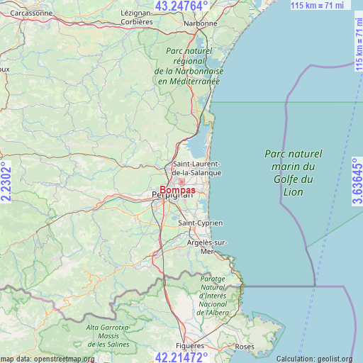
Bompas GPS coordinates[2]
42° 43' 59.988" North, 2° 55' 59.988" East
| Map corner | latitude | longitude |
|---|---|---|
| Upper-left | 43.24764°, | 2.2302° |
| Center: | 42.73333°, | 2.93333° |
| Lower-right: | 42.21472°, | 3.63645° |
| Map W x H: | 114.8×114.8 km | = 71.3×71.3mi |
| max Lat: | 51.07786° ⇑98.9% North |
| Bompas: | 42.73333° |
| min Lat: | ⇓1.1% South 41.3874° |
| min Long | Bompas | max Long |
| -5.08615° | 2.93333° | 9.52242° |
| W 56.8%⇐ | ⇒43.2% E |
Elevation
Elevation of Bompas is 16 m = 52 ft, and this is 177.7 m = 583 ft below average elevation for this country.
| Max E: |
2333 m = 7654 ft | 95.4% |
| Avg. | 193.7 m = 635 ft | |
| Bompas | 16 m = 52 ft | |
Min E: |
-1 m = -3 ft | 4.6% |
See also: France elevation on elevation.city.
Geographical zone
Bompas is located in North temperate zone (between Tropic of Cancer and the Arctic Circle). Distance of this Northern Tropic circle is 2145.6 km =1333.2 mi to South.| Distance of | km | miles | from Bompas |
|---|---|---|---|
| North Pole | 5255.6 | 3265.7 | to North |
| Arctic Circle | 2649.7 | 1646.4 | to North |
| Tropic Cancer | 2145.6 | 1333.2 | to South |
| Equator | 4751.5 | 2952.4 | to South |


Nearby cities:
15 places around Bompas: (largest is in red/bold)
• Cabestany
5.8 km =3.6 mi,  173°
173°
• Canet-en-Roussillon
7.8 km =4.8 mi,  118°
118°
• Claira
3.5 km =2.2 mi,  31°
31°
• Perpignan
5 km =3.1 mi,  217°
217°
• Peyrestortes
7 km =4.3 mi,  289°
289°
• Pia
1.7 km =1.1 mi,  318°
318°
• Rivesaltes
6.4 km =4 mi,  308°
308°
• Saint-Estève
7.6 km =4.7 mi,  251°
251°
• Saint-Hippolyte
6.4 km =4 mi,  24°
24°
• Saint-Laurent-de-la-Salanque
6.4 km =4 mi,  46°
46°
• Saint-Nazaire
8.7 km =5.4 mi,  146°
146°
• Sainte-Marie-Plage
8.6 km =5.3 mi,  96°
96°
• Saleilles
8.9 km =5.5 mi, 169°
• Torreilles
5.4 km =3.4 mi,  64°
64°
• Villelongue-de-la-Salanque
4.1 km =2.5 mi, 100°
Sources, notices
• [Note1] Compared only with cities in France existing in our database
• [Src1] Map data: © OpenStreetMap contributors (CC-BY-SA)
• [Src2] Other city data from geonames.org with taken over terms of usage.
• [Src3] Geographical zone / Annual Mean Temperature by Robert A. Rohde @ Wikipedia
