Pérols geodata
Pérols (Occitanie) is a populated place; located in France in Europe/Paris (GMT+2) time zone. With population of 8,753 people, there are 1095 cities with bigger population in this country. Compared to other cities in France, 92.3% of cities are located further ↑North; 67.4% of cities are located further ←West and 97.8% of cities have higher elevation than Pérols. Note1
Administrative division(s):
- Level 1: Occitanie
- Level 2: Département de l'Hérault
- Level 3: Arrondissement of Montpellier
- Level 4: Pérols


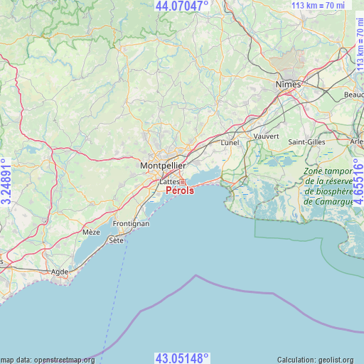
Pérols GPS coordinates[2]
43° 33' 47.268" North, 3° 57' 7.308" East
| Map corner | latitude | longitude |
|---|---|---|
| Upper-left | 44.07047°, | 3.24891° |
| Center: | 43.56313°, | 3.95203° |
| Lower-right: | 43.05148°, | 4.65516° |
| Map W x H: | 113.3×113.3 km | = 70.4×70.4mi |
| max Lat: | 51.07786° ⇑92.3% North |
| Pérols: | 43.56313° |
| min Lat: | ⇓7.7% South 41.3874° |
| min Long | Pérols | max Long |
| -5.08615° | 3.95203° | 9.52242° |
| W 67.4%⇐ | ⇒32.6% E |
Elevation
Elevation of Pérols is 9 m = 30 ft, and this is 184.7 m = 606 ft below average elevation for this country.
| Max E: |
2333 m = 7654 ft | 97.8% |
| Avg. | 193.7 m = 635 ft | |
| Pérols | 9 m = 30 ft | |
Min E: |
-1 m = -3 ft | 2.2% |
See also: France elevation on elevation.city.
Geographical zone
Pérols is located in North temperate zone (between Tropic of Cancer and the Arctic Circle). Distance of this Northern Tropic circle is 2237.8 km =1390.5 mi to South.| Distance of | km | miles | from Pérols |
|---|---|---|---|
| North Pole | 5163.3 | 3208.3 | to North |
| Arctic Circle | 2557.4 | 1589.1 | to North |
| Tropic Cancer | 2237.8 | 1390.5 | to South |
| Equator | 4843.8 | 3009.8 | to South |


Nearby cities:
15 places around Pérols: (largest is in red/bold)
• Candillargues
11.4 km =7.1 mi,  55°
55°
• Castelnau-le-Lez
8.9 km =5.5 mi,  331°
331°
• Clapiers
11.7 km =7.3 mi, 334°
• Jacou
11.4 km =7.1 mi,  343°
343°
• La Grande-Motte
10.6 km =6.6 mi,  87°
87°
• Lattes
3.9 km =2.4 mi,  277°
277°
• Le Crès
9.5 km =5.9 mi,  354°
354°
• Mauguio
7.6 km =4.7 mi,  36°
36°
• Montpellier
8 km =5 mi,  311°
311°
• Mudaison
10.2 km =6.3 mi, 39°
• Palavas-les-Flots
4.4 km =2.7 mi,  207°
207°
• Saint-Aunès
8.7 km =5.4 mi,  7°
7°
• Saint-Jean-de-Védas
10.3 km =6.4 mi, 279°
• Vendargues
10.7 km =6.6 mi, 7°
• Villeneuve-lès-Maguelone
7.6 km =4.7 mi,  244°
244°
Sources, notices
• [Note1] Compared only with cities in France existing in our database
• [Src1] Map data: © OpenStreetMap contributors (CC-BY-SA)
• [Src2] Other city data from geonames.org with taken over terms of usage.
• [Src3] Geographical zone / Annual Mean Temperature by Robert A. Rohde @ Wikipedia
