Pelousey geodata
Pelousey (Bourgogne-Franche-Comté) is a populated place; located in France in Europe/Paris (GMT+2) time zone. With population of 1,268 people, there are 7192 cities with bigger population in this country. Compared to other cities in France, 51.9% of cities are located further ↑North; 86.2% of cities are located further ←West and 72% of cities have lower elevation than Pelousey. Note1
Administrative division(s):
- Level 1: Bourgogne-Franche-Comté
- Level 2: Doubs
- Level 3: Arrondissement de Besançon
- Level 4: Pelousey


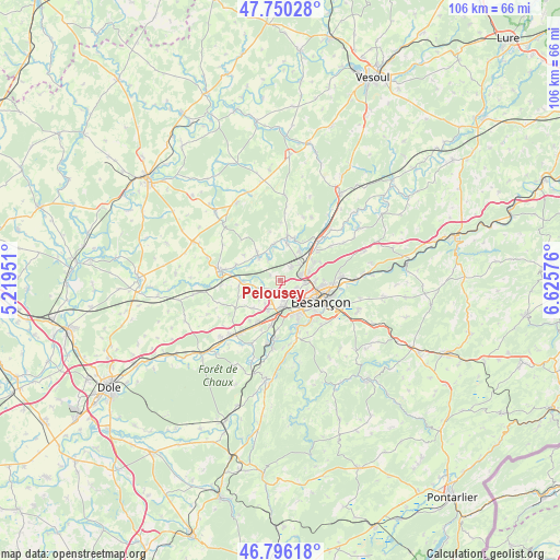
Pelousey GPS coordinates[2]
47° 16' 31.368" North, 5° 55' 21.468" East
| Map corner | latitude | longitude |
|---|---|---|
| Upper-left | 47.75028°, | 5.21951° |
| Center: | 47.27538°, | 5.92263° |
| Lower-right: | 46.79618°, | 6.62576° |
| Map W x H: | 106.1×106.1 km | = 65.9×65.9mi |
| max Lat: | 51.07786° ⇑51.9% North |
| Pelousey: | 47.27538° |
| min Lat: | ⇓48.1% South 41.3874° |
| min Long | Pelousey | max Long |
| -5.08615° | 5.92263° | 9.52242° |
| W 86.2%⇐ | ⇒13.8% E |
Elevation
Elevation of Pelousey is 230 m = 755 ft, and this is 36.3 m = 119 ft above average elevation for this country.
| Max E: |
2333 m = 7654 ft | 28% |
| Pelousey | 230 m 755 ft | |
| Avg. | 193.7 m = 635 ft | |
Min E: |
-1 m = -3 ft | 72% |
See also: France elevation on elevation.city.
Geographical zone
Pelousey is located in North temperate zone (between Tropic of Cancer and the Arctic Circle). Distance of this North polar circle is 2144.6 km =1332.6 mi to North.| Distance of | km | miles | from Pelousey |
|---|---|---|---|
| North Pole | 4750.5 | 2951.8 | to North |
| Arctic Circle | 2144.6 | 1332.6 | to North |
| Tropic Cancer | 2650.6 | 1647 | to South |
| Equator | 5256.5 | 3266.2 | to South |


Nearby cities:
15 places around Pelousey: (largest is in red/bold)
• Auxon-Dessous
3.4 km =2.1 mi,  37°
37°
• Auxon-Dessus
3.5 km =2.2 mi,  45°
45°
• Chaucenne
2.1 km =1.3 mi,  297°
297°
• Chemaudin
6.1 km =3.8 mi,  200°
200°
• Châtillon-le-Duc
7.2 km =4.5 mi,  62°
62°
• Franois
5 km =3.1 mi,  174°
174°
• Geneuille
6.4 km =4 mi,  33°
33°
• Miserey-Salines
4.1 km =2.5 mi,  72°
72°
• Pin
6.2 km =3.9 mi,  317°
317°
• Pirey
3.5 km =2.2 mi,  116°
116°
• Pouilley-les-Vignes
2.2 km =1.4 mi,  153°
153°
• Recologne
7 km =4.3 mi,  267°
267°
• Serre-les-Sapins
2.9 km =1.8 mi,  164°
164°
• École-Valentin
4.7 km =2.9 mi,  101°
101°
• Émagny
5.7 km =3.5 mi,  314°
314°
Sources, notices
• [Note1] Compared only with cities in France existing in our database
• [Src1] Map data: © OpenStreetMap contributors (CC-BY-SA)
• [Src2] Other city data from geonames.org with taken over terms of usage.
• [Src3] Geographical zone / Annual Mean Temperature by Robert A. Rohde @ Wikipedia
