Pamproux geodata
Pamproux (Nouvelle-Aquitaine) is a populated place; located in France in Europe/Paris (GMT+2) time zone. With population of 1,682 people, there are 5567 cities with bigger population in this country. Compared to other cities in France, 61.1% of cities are located further ↑North; 78.5% of cities are located further →East and 61.5% of cities have higher elevation than Pamproux. Note1
Administrative division(s):
- Level 1: Nouvelle-Aquitaine
- Level 2: Département des Deux-Sèvres
- Level 3: Arrondissement de Niort
- Level 4: Pamproux


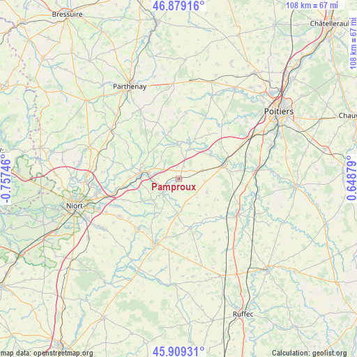
Pamproux GPS coordinates[2]
46° 23' 47.004" North, 0° 3' 15.624" West
| Map corner | latitude | longitude |
|---|---|---|
| Upper-left | 46.87916°, | -0.75746° |
| Center: | 46.39639°, | -0.05434° |
| Lower-right: | 45.90931°, | 0.64879° |
| Map W x H: | 107.8×107.8 km | = 67×67mi |
| max Lat: | 51.07786° ⇑61.1% North |
| Pamproux: | 46.39639° |
| min Lat: | ⇓38.9% South 41.3874° |
| min Long | Pamproux | max Long |
| -5.08615° | -0.05434° | 9.52242° |
| W 21.5%⇐ | ⇒78.5% E |
Elevation
Elevation of Pamproux is 98 m = 322 ft, and this is 95.7 m = 314 ft below average elevation for this country.
| Max E: |
2333 m = 7654 ft | 61.5% |
| Avg. | 193.7 m = 635 ft | |
| Pamproux | 98 m = 322 ft | |
Min E: |
-1 m = -3 ft | 38.5% |
See also: France elevation on elevation.city.
Geographical zone
Pamproux is located in North temperate zone (between Tropic of Cancer and the Arctic Circle). Distance of this North polar circle is 2242.4 km =1393.4 mi to North.| Distance of | km | miles | from Pamproux |
|---|---|---|---|
| North Pole | 4848.3 | 3012.6 | to North |
| Arctic Circle | 2242.4 | 1393.4 | to North |
| Tropic Cancer | 2552.9 | 1586.3 | to South |
| Equator | 5158.8 | 3205.5 | to South |


Nearby cities:
15 places around Pamproux: (largest is in red/bold)
• Chenay
8.1 km =5 mi,  168°
168°
• Chey
10.3 km =6.4 mi,  178°
178°
• Exireuil
11.3 km =7 mi,  291°
291°
• Exoudun
6.2 km =3.9 mi,  200°
200°
• Jazeneuil
12.1 km =7.5 mi,  50°
50°
• La Mothe-Saint-Héray
6 km =3.7 mi,  228°
228°
• Lusignan
14.2 km =8.8 mi,  72°
72°
• Ménigoute
11.1 km =6.9 mi,  358°
358°
• Nanteuil
9.4 km =5.8 mi,  280°
280°
• Romans
13.9 km =8.6 mi,  252°
252°
• Rouillé
7.7 km =4.8 mi, 69°
• Saint-Martin-de-Saint-Maixent
10.7 km =6.6 mi,  269°
269°
• Saint-Sauvant
9.3 km =5.8 mi,  114°
114°
• Sainte-Eanne
7.5 km =4.7 mi,  258°
258°
• Sanxay
11.4 km =7.1 mi,  18°
18°
Sources, notices
• [Note1] Compared only with cities in France existing in our database
• [Src1] Map data: © OpenStreetMap contributors (CC-BY-SA)
• [Src2] Other city data from geonames.org with taken over terms of usage.
• [Src3] Geographical zone / Annual Mean Temperature by Robert A. Rohde @ Wikipedia
