Nanteuil geodata
Nanteuil (Nouvelle-Aquitaine) is a populated place; located in France in Europe/Paris (GMT+2) time zone. With population of 1,604 people, there are 5819 cities with bigger population in this country. Compared to other cities in France, 60.9% of cities are located further ↑North; 79.4% of cities are located further →East and 70.5% of cities have higher elevation than Nanteuil. Note1
Administrative division(s):
- Level 1: Nouvelle-Aquitaine
- Level 2: Département des Deux-Sèvres
- Level 3: Arrondissement de Niort
- Level 4: Nanteuil


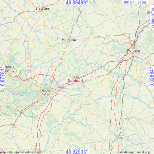
Nanteuil GPS coordinates[2]
46° 24' 44.136" North, 0° 10' 28.164" West
| Map corner | latitude | longitude |
|---|---|---|
| Upper-left | 46.89489°, | -0.87761° |
| Center: | 46.41226°, | -0.17449° |
| Lower-right: | 45.92533°, | 0.52864° |
| Map W x H: | 107.8×107.8 km | = 67×67mi |
| max Lat: | 51.07786° ⇑60.9% North |
| Nanteuil: | 46.41226° |
| min Lat: | ⇓39.1% South 41.3874° |
| min Long | Nanteuil | max Long |
| -5.08615° | -0.17449° | 9.52242° |
| W 20.6%⇐ | ⇒79.4% E |
Elevation
Elevation of Nanteuil is 77 m = 253 ft, and this is 116.7 m = 383 ft below average elevation for this country.
| Max E: |
2333 m = 7654 ft | 70.5% |
| Avg. | 193.7 m = 635 ft | |
| Nanteuil | 77 m = 253 ft | |
Min E: |
-1 m = -3 ft | 29.5% |
See also: France elevation on elevation.city.
Geographical zone
Nanteuil is located in North temperate zone (between Tropic of Cancer and the Arctic Circle). Distance of this North polar circle is 2240.6 km =1392.2 mi to North.| Distance of | km | miles | from Nanteuil |
|---|---|---|---|
| North Pole | 4846.5 | 3011.5 | to North |
| Arctic Circle | 2240.6 | 1392.2 | to North |
| Tropic Cancer | 2554.6 | 1587.4 | to South |
| Equator | 5160.6 | 3206.6 | to South |


Nearby cities:
15 places around Nanteuil: (largest is in red/bold)
• Augé
9.2 km =5.7 mi,  289°
289°
• Azay-le-Brûlé
5.7 km =3.5 mi,  257°
257°
• Exireuil
2.7 km =1.7 mi,  329°
329°
• Exoudun
10.4 km =6.5 mi,  136°
136°
• La Crèche
10.9 km =6.8 mi,  242°
242°
• La Mothe-Saint-Héray
7.4 km =4.6 mi, 140°
• Ménigoute
12.9 km =8 mi,  43°
43°
• Pamproux
9.4 km =5.8 mi,  100°
100°
• Prailles
10.6 km =6.6 mi,  198°
198°
• Romans
7.2 km =4.5 mi,  214°
214°
• Saint-Georges-de-Noisné
11 km =6.8 mi,  324°
324°
• Saint-Martin-de-Saint-Maixent
2.4 km =1.5 mi,  217°
217°
• Sainte-Eanne
3.7 km =2.3 mi,  149°
149°
• Sainte-Néomaye
7.8 km =4.8 mi, 236°
• Saivres
5.3 km =3.3 mi,  295°
295°
Sources, notices
• [Note1] Compared only with cities in France existing in our database
• [Src1] Map data: © OpenStreetMap contributors (CC-BY-SA)
• [Src2] Other city data from geonames.org with taken over terms of usage.
• [Src3] Geographical zone / Annual Mean Temperature by Robert A. Rohde @ Wikipedia
