Chey geodata
Chey (Nouvelle-Aquitaine) is a populated place; located in France in Europe/Paris (GMT+2) time zone. With population of 601 people, there are 13304 cities with bigger population in this country. Compared to other cities in France, 62.3% of cities are located further ↑North; 78.5% of cities are located further →East and 51.1% of cities have lower elevation than Chey. Note1
Administrative division(s):
- Level 1: Nouvelle-Aquitaine
- Level 2: Département des Deux-Sèvres
- Level 3: Arrondissement de Niort
- Level 4: Chey


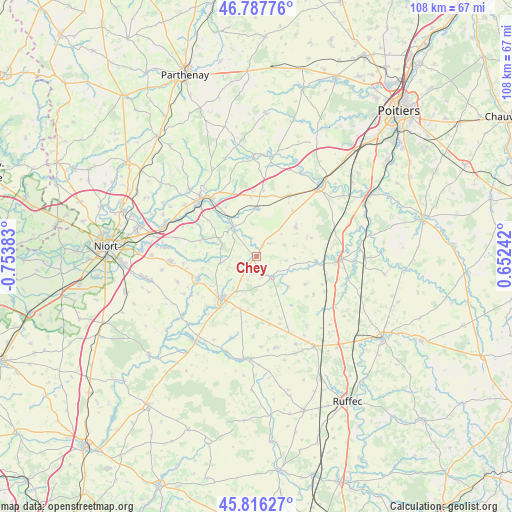
Chey GPS coordinates[2]
46° 18' 15.012" North, 0° 3' 2.52" West
| Map corner | latitude | longitude |
|---|---|---|
| Upper-left | 46.78776°, | -0.75383° |
| Center: | 46.30417°, | -0.0507° |
| Lower-right: | 45.81627°, | 0.65242° |
| Map W x H: | 108×108 km | = 67.1×67.1mi |
| max Lat: | 51.07786° ⇑62.3% North |
| Chey: | 46.30417° |
| min Lat: | ⇓37.7% South 41.3874° |
| min Long | Chey | max Long |
| -5.08615° | -0.0507° | 9.52242° |
| W 21.5%⇐ | ⇒78.5% E |
Elevation
Elevation of Chey is 136 m = 446 ft, and this is 57.7 m = 189 ft below average elevation for this country.
| Max E: |
2333 m = 7654 ft | 48.9% |
| Avg. | 193.7 m = 635 ft | |
| Chey | 136 m = 446 ft | |
Min E: |
-1 m = -3 ft | 51.1% |
See also: France elevation on elevation.city.
Geographical zone
Chey is located in North temperate zone (between Tropic of Cancer and the Arctic Circle). Distance of this North polar circle is 2252.6 km =1399.7 mi to North.| Distance of | km | miles | from Chey |
|---|---|---|---|
| North Pole | 4858.5 | 3018.9 | to North |
| Arctic Circle | 2252.6 | 1399.7 | to North |
| Tropic Cancer | 2542.6 | 1579.9 | to South |
| Equator | 5148.5 | 3199.1 | to South |


Nearby cities:
15 places around Chey: (largest is in red/bold)
• Celles-sur-Belle
13.2 km =8.2 mi,  249°
249°
• Chenay
2.7 km =1.7 mi,  28°
28°
• Clussais
14.2 km =8.8 mi,  147°
147°
• Exoudun
5.1 km =3.2 mi,  331°
331°
• La Mothe-Saint-Héray
7.9 km =4.9 mi,  322°
322°
• Lezay
5.4 km =3.4 mi,  143°
143°
• Melle
11.4 km =7.1 mi,  218°
218°
• Pamproux
10.3 km =6.4 mi,  358°
358°
• Prailles
13.1 km =8.1 mi,  278°
278°
• Rom
12.8 km =8 mi,  95°
95°
• Saint-Martin-lès-Melle
12.7 km =7.9 mi, 223°
• Saint-Sauvant
10.4 km =6.5 mi,  52°
52°
• Saint-Vincent-la-Châtre
9.3 km =5.8 mi,  173°
173°
• Sainte-Eanne
11.6 km =7.2 mi, 319°
• Vitré
11.6 km =7.2 mi,  257°
257°
Sources, notices
• [Note1] Compared only with cities in France existing in our database
• [Src1] Map data: © OpenStreetMap contributors (CC-BY-SA)
• [Src2] Other city data from geonames.org with taken over terms of usage.
• [Src3] Geographical zone / Annual Mean Temperature by Robert A. Rohde @ Wikipedia
