Montaut geodata
Montaut (Occitanie) is a populated place; located in France in Europe/Paris (GMT+2) time zone. With population of 685 people, there are 12013 cities with bigger population in this country. Compared to other cities in France, 97.3% of cities are located further ↑North; 61% of cities are located further →East and 77.9% of cities have lower elevation than Montaut. Note1
Administrative division(s):
- Level 1: Occitanie
- Level 2: Département de l'Ariège
- Level 3: Arrondissement de Pamiers
- Level 4: Montaut


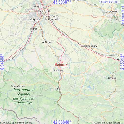
Montaut GPS coordinates[2]
43° 10' 59.988" North, 1° 39' 0" East
| Map corner | latitude | longitude |
|---|---|---|
| Upper-left | 43.69387°, | 0.94688° |
| Center: | 43.18333°, | 1.65° |
| Lower-right: | 42.66848°, | 2.35313° |
| Map W x H: | 114×114 km | = 70.8×70.8mi |
| max Lat: | 51.07786° ⇑97.3% North |
| Montaut: | 43.18333° |
| min Lat: | ⇓2.7% South 41.3874° |
| min Long | Montaut | max Long |
| -5.08615° | 1.65° | 9.52242° |
| W 39%⇐ | ⇒61% E |
Elevation
Elevation of Montaut is 271 m = 889 ft, and this is 77.3 m = 254 ft above average elevation for this country.
| Max E: |
2333 m = 7654 ft | 22.1% |
| Montaut | 271 m 889 ft | |
| Avg. | 193.7 m = 635 ft | |
Min E: |
-1 m = -3 ft | 77.9% |
See also: France elevation on elevation.city.
Geographical zone
Montaut is located in North temperate zone (between Tropic of Cancer and the Arctic Circle). Distance of this Northern Tropic circle is 2195.6 km =1364.3 mi to South.| Distance of | km | miles | from Montaut |
|---|---|---|---|
| North Pole | 5205.5 | 3234.5 | to North |
| Arctic Circle | 2599.6 | 1615.3 | to North |
| Tropic Cancer | 2195.6 | 1364.3 | to South |
| Equator | 4801.5 | 2983.5 | to South |


Nearby cities:
15 places around Montaut: (largest is in red/bold)
• Belpech
8.4 km =5.2 mi,  77°
77°
• Bonnac
5.1 km =3.2 mi,  247°
247°
• Calmont
11.7 km =7.3 mi,  352°
352°
• La Tour-du-Crieu
8.7 km =5.4 mi,  178°
178°
• Le Vernet
3.8 km =2.4 mi,  272°
272°
• Les Pujols
12 km =7.5 mi,  152°
152°
• Mazères
7.8 km =4.8 mi,  16°
16°
• Pamiers
8.1 km =5 mi,  203°
203°
• Rieux-de-Pelleport
14.4 km =8.9 mi,  193°
193°
• Saint-Jean-du-Falga
10.9 km =6.8 mi, 189°
• Salles-sur-l’Hers
16.4 km =10.2 mi,  41°
41°
• Saverdun
8.4 km =5.2 mi,  313°
313°
• Varilhes
15.5 km =9.6 mi, 186°
• Verniolle
11.3 km =7 mi, 180°
• Villeneuve-du-Paréage
3.4 km =2.1 mi, 197°
Sources, notices
• [Note1] Compared only with cities in France existing in our database
• [Src1] Map data: © OpenStreetMap contributors (CC-BY-SA)
• [Src2] Other city data from geonames.org with taken over terms of usage.
• [Src3] Geographical zone / Annual Mean Temperature by Robert A. Rohde @ Wikipedia
