Saverdun geodata
Saverdun (Occitanie) is a populated place; located in France in Europe/Paris (GMT+2) time zone. With population of 3,901 people, there are 2519 cities with bigger population in this country. Compared to other cities in France, 96.7% of cities are located further ↑North; 62.1% of cities are located further →East and 73% of cities have lower elevation than Saverdun. Note1
Administrative division(s):
- Level 1: Occitanie
- Level 2: Département de l'Ariège
- Level 3: Arrondissement de Pamiers
- Level 4: Saverdun


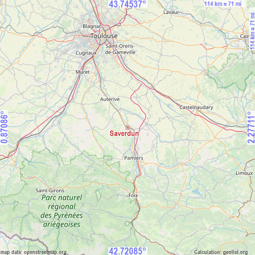
Saverdun GPS coordinates[2]
43° 14' 6.936" North, 1° 34' 26.328" East
| Map corner | latitude | longitude |
|---|---|---|
| Upper-left | 43.74537°, | 0.87086° |
| Center: | 43.23526°, | 1.57398° |
| Lower-right: | 42.72085°, | 2.27711° |
| Map W x H: | 113.9×113.9 km | = 70.8×70.8mi |
| max Lat: | 51.07786° ⇑96.7% North |
| Saverdun: | 43.23526° |
| min Lat: | ⇓3.3% South 41.3874° |
| min Long | Saverdun | max Long |
| -5.08615° | 1.57398° | 9.52242° |
| W 37.9%⇐ | ⇒62.1% E |
Elevation
Elevation of Saverdun is 236 m = 774 ft, and this is 42.3 m = 139 ft above average elevation for this country.
| Max E: |
2333 m = 7654 ft | 27% |
| Saverdun | 236 m 774 ft | |
| Avg. | 193.7 m = 635 ft | |
Min E: |
-1 m = -3 ft | 73% |
See also: France elevation on elevation.city.
Geographical zone
Saverdun is located in North temperate zone (between Tropic of Cancer and the Arctic Circle). Distance of this Northern Tropic circle is 2201.4 km =1367.9 mi to South.| Distance of | km | miles | from Saverdun |
|---|---|---|---|
| North Pole | 5199.8 | 3231 | to North |
| Arctic Circle | 2593.9 | 1611.8 | to North |
| Tropic Cancer | 2201.4 | 1367.9 | to South |
| Equator | 4807.3 | 2987.1 | to South |


Nearby cities:
15 places around Saverdun: (largest is in red/bold)
• Artigat
15.4 km =9.6 mi,  225°
225°
• Auterive
15 km =9.3 mi,  328°
328°
• Belpech
14.9 km =9.3 mi,  105°
105°
• Bonnac
7.8 km =4.8 mi,  169°
169°
• Calmont
7.4 km =4.6 mi,  38°
38°
• Cintegabelle
9.3 km =5.8 mi,  339°
339°
• Gaillac-Toulza
8.6 km =5.3 mi,  285°
285°
• Le Fossat
15.1 km =9.4 mi,  243°
243°
• Le Vernet
6.1 km =3.8 mi,  157°
157°
• Mazères
8.5 km =5.3 mi,  78°
78°
• Montaut
8.4 km =5.2 mi,  133°
133°
• Nailloux
14.1 km =8.8 mi,  16°
16°
• Pamiers
13.5 km =8.4 mi, 167°
• Saint-Ybars
15.2 km =9.4 mi,  270°
270°
• Villeneuve-du-Paréage
10.4 km =6.5 mi,  150°
150°
Sources, notices
• [Note1] Compared only with cities in France existing in our database
• [Src1] Map data: © OpenStreetMap contributors (CC-BY-SA)
• [Src2] Other city data from geonames.org with taken over terms of usage.
• [Src3] Geographical zone / Annual Mean Temperature by Robert A. Rohde @ Wikipedia
