Pagny-sur-Moselle geodata
Pagny-sur-Moselle (Grand Est) is a populated place; located in France in Europe/Paris (GMT+2) time zone. With population of 4,149 people, there are 2365 cities with bigger population in this country. Compared to other cities in France, 79.3% of cities are located further ↓South; 87.2% of cities are located further ←West and 63.1% of cities have lower elevation than Pagny-sur-Moselle. Note1
Administrative division(s):
- Level 1: Grand Est
- Level 2: Meurthe-et-Moselle
- Level 3: Arrondissement de Nancy
- Level 4: Pagny-sur-Moselle


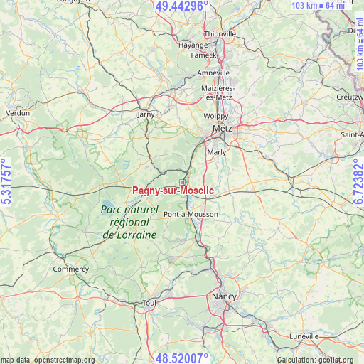
Pagny-sur-Moselle GPS coordinates[2]
48° 59' 1.14" North, 6° 1' 14.484" East
| Map corner | latitude | longitude |
|---|---|---|
| Upper-left | 49.44296°, | 5.31757° |
| Center: | 48.98365°, | 6.02069° |
| Lower-right: | 48.52007°, | 6.72382° |
| Map W x H: | 102.6×102.6 km | = 63.8×63.8mi |
| max Lat: | 51.07786° ⇑20.7% North |
| Pagny-sur-Moselle: | 48.98365° |
| min Lat: | ⇓79.3% South 41.3874° |
| min Long | Pagny-sur-Mosel | max Long |
| -5.08615° | 6.02069° | 9.52242° |
| W 87.2%⇐ | ⇒12.8% E |
Elevation
Elevation of Pagny-sur-Moselle is 185 m = 607 ft, and this is 8.7 m = 29 ft below average elevation for this country.
| Max E: |
2333 m = 7654 ft | 36.9% |
| Avg. | 193.7 m = 635 ft | |
| Pagny-sur-Moselle | 185 m = 607 ft | |
Min E: |
-1 m = -3 ft | 63.1% |
See also: France elevation on elevation.city.
Geographical zone
Pagny-sur-Moselle is located in North temperate zone (between Tropic of Cancer and the Arctic Circle). Distance of this North polar circle is 1954.7 km =1214.6 mi to North.| Distance of | km | miles | from Pagny-sur-Moselle |
|---|---|---|---|
| North Pole | 4560.6 | 2833.8 | to North |
| Arctic Circle | 1954.7 | 1214.6 | to North |
| Tropic Cancer | 2840.6 | 1765.1 | to South |
| Equator | 5446.5 | 3384.3 | to South |


Nearby cities:
15 places around Pagny-sur-Moselle: (largest is in red/bold)
• Ancy-sur-Moselle
8.6 km =5.3 mi,  18°
18°
• Arnaville
3.2 km =2 mi,  12°
12°
• Cheminot
9.5 km =5.9 mi,  114°
114°
• Corny-sur-Moselle
6.5 km =4 mi,  26°
26°
• Féy
7.7 km =4.8 mi,  48°
48°
• Gorze
7.8 km =4.8 mi,  349°
349°
• Lorry
4.8 km =3 mi,  82°
82°
• Maidières
9.5 km =5.9 mi,  171°
171°
• Marieulles
6.1 km =3.8 mi,  72°
72°
• Montauville
9.2 km =5.7 mi,  178°
178°
• Norroy-lès-Pont-à-Mousson
5.5 km =3.4 mi, 172°
• Novéant-sur-Moselle
4.9 km =3 mi, 24°
• Onville
5.3 km =3.3 mi,  314°
314°
• Pont-à-Mousson
8.9 km =5.5 mi,  163°
163°
• Vandières
3.5 km =2.2 mi, 164°
Sources, notices
• [Note1] Compared only with cities in France existing in our database
• [Src1] Map data: © OpenStreetMap contributors (CC-BY-SA)
• [Src2] Other city data from geonames.org with taken over terms of usage.
• [Src3] Geographical zone / Annual Mean Temperature by Robert A. Rohde @ Wikipedia
