Féy geodata
Féy (Grand Est) is a populated place; located in France in Europe/Paris (GMT+2) time zone. With population of 582 people, there are 13612 cities with bigger population in this country. Compared to other cities in France, 80.4% of cities are located further ↓South; 88.2% of cities are located further ←West and 69.2% of cities have lower elevation than Féy. Note1
Administrative division(s):
- Level 1: Grand Est
- Level 2: Moselle
- Level 3: Arrondissement de Metz
- Level 4: Féy


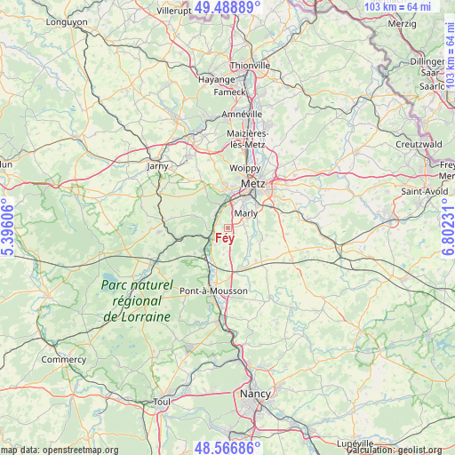
Féy GPS coordinates[2]
49° 1' 48.036" North, 6° 5' 57.084" East
| Map corner | latitude | longitude |
|---|---|---|
| Upper-left | 49.48889°, | 5.39606° |
| Center: | 49.03001°, | 6.09919° |
| Lower-right: | 48.56686°, | 6.80231° |
| Map W x H: | 102.5×102.5 km | = 63.7×63.7mi |
| max Lat: | 51.07786° ⇑19.6% North |
| Féy: | 49.03001° |
| min Lat: | ⇓80.4% South 41.3874° |
| min Long | Féy | max Long |
| -5.08615° | 6.09919° | 9.52242° |
| W 88.2%⇐ | ⇒11.8% E |
Elevation
Elevation of Féy is 215 m = 705 ft, and this is 21.3 m = 70 ft above average elevation for this country.
| Max E: |
2333 m = 7654 ft | 30.8% |
| Féy | 215 m 705 ft | |
| Avg. | 193.7 m = 635 ft | |
Min E: |
-1 m = -3 ft | 69.2% |
See also: France elevation on elevation.city.
Geographical zone
Féy is located in North temperate zone (between Tropic of Cancer and the Arctic Circle). Distance of this North polar circle is 1949.5 km =1211.4 mi to North.| Distance of | km | miles | from Féy |
|---|---|---|---|
| North Pole | 4555.4 | 2830.6 | to North |
| Arctic Circle | 1949.5 | 1211.4 | to North |
| Tropic Cancer | 2845.7 | 1768.2 | to South |
| Equator | 5451.6 | 3387.5 | to South |


Nearby cities:
15 places around Féy: (largest is in red/bold)
• Ancy-sur-Moselle
4.2 km =2.6 mi,  314°
314°
• Arnaville
5.5 km =3.4 mi,  247°
247°
• Ars-sur-Moselle
5.6 km =3.5 mi,  341°
341°
• Augny
3.7 km =2.3 mi,  21°
21°
• Coin-lès-Cuvry
4.2 km =2.6 mi,  83°
83°
• Corny-sur-Moselle
2.9 km =1.8 mi,  282°
282°
• Cuvry
4.6 km =2.9 mi,  71°
71°
• Jouy-aux-Arches
3.8 km =2.4 mi, 337°
• Lorry
4.6 km =2.9 mi,  191°
191°
• Marieulles
3.3 km =2.1 mi,  178°
178°
• Marly
5.5 km =3.4 mi,  46°
46°
• Novéant-sur-Moselle
3.8 km =2.4 mi,  259°
259°
• Pommérieux
6.6 km =4.1 mi,  124°
124°
• Pouilly
6.7 km =4.2 mi, 70°
• Pournoy-la-Chétive
4.2 km =2.6 mi,  106°
106°
Sources, notices
• [Note1] Compared only with cities in France existing in our database
• [Src1] Map data: © OpenStreetMap contributors (CC-BY-SA)
• [Src2] Other city data from geonames.org with taken over terms of usage.
• [Src3] Geographical zone / Annual Mean Temperature by Robert A. Rohde @ Wikipedia
