Novéant-sur-Moselle geodata
Novéant-sur-Moselle (Grand Est) is a populated place; located in France in Europe/Paris (GMT+2) time zone. With population of 1,867 people, there are 5090 cities with bigger population in this country. Compared to other cities in France, 80.3% of cities are located further ↓South; 87.6% of cities are located further ←West and 60.5% of cities have lower elevation than Novéant-sur-Moselle. Note1
Administrative division(s):
- Level 1: Grand Est
- Level 2: Moselle
- Level 3: Arrondissement de Metz
- Level 4: Novéant-sur-Moselle


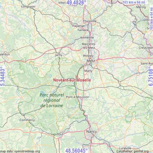
Novéant-sur-Moselle GPS coordinates[2]
49° 1' 25.176" North, 6° 2' 52.62" East
| Map corner | latitude | longitude |
|---|---|---|
| Upper-left | 49.4826°, | 5.34483° |
| Center: | 49.02366°, | 6.04795° |
| Lower-right: | 48.56045°, | 6.75108° |
| Map W x H: | 102.5×102.5 km | = 63.7×63.7mi |
| max Lat: | 51.07786° ⇑19.7% North |
| Novéant-sur-Moselle: | 49.02366° |
| min Lat: | ⇓80.3% South 41.3874° |
| min Long | Novéant-sur-Mo | max Long |
| -5.08615° | 6.04795° | 9.52242° |
| W 87.6%⇐ | ⇒12.4% E |
Elevation
Elevation of Novéant-sur-Moselle is 172 m = 564 ft, and this is 21.7 m = 71 ft below average elevation for this country.
| Max E: |
2333 m = 7654 ft | 39.5% |
| Avg. | 193.7 m = 635 ft | |
| Novéant-sur-Moselle | 172 m = 564 ft | |
Min E: |
-1 m = -3 ft | 60.5% |
See also: France elevation on elevation.city.
Geographical zone
Novéant-sur-Moselle is located in North temperate zone (between Tropic of Cancer and the Arctic Circle). Distance of this North polar circle is 1950.3 km =1211.9 mi to North.| Distance of | km | miles | from Novéant-sur-Moselle |
|---|---|---|---|
| North Pole | 4556.1 | 2831 | to North |
| Arctic Circle | 1950.3 | 1211.9 | to North |
| Tropic Cancer | 2845 | 1767.8 | to South |
| Equator | 5450.9 | 3387 | to South |


Nearby cities:
15 places around Novéant-sur-Moselle: (largest is in red/bold)
• Ancy-sur-Moselle
3.8 km =2.4 mi,  10°
10°
• Arnaville
1.9 km =1.2 mi,  223°
223°
• Ars-sur-Moselle
6.3 km =3.9 mi,  17°
17°
• Augny
6.6 km =4.1 mi,  50°
50°
• Coin-lès-Cuvry
8 km =5 mi,  81°
81°
• Corny-sur-Moselle
1.6 km =1 mi,  35°
35°
• Féy
3.8 km =2.4 mi, 79°
• Gorze
4.7 km =2.9 mi,  312°
312°
• Jouy-aux-Arches
4.8 km =3 mi,  28°
28°
• Lorry
4.7 km =2.9 mi,  143°
143°
• Marieulles
4.6 km =2.9 mi,  124°
124°
• Onville
5.8 km =3.6 mi,  262°
262°
• Pagny-sur-Moselle
4.9 km =3 mi,  204°
204°
• Pournoy-la-Chétive
7.8 km =4.8 mi,  93°
93°
• Vandières
7.9 km =4.9 mi,  187°
187°
Sources, notices
• [Note1] Compared only with cities in France existing in our database
• [Src1] Map data: © OpenStreetMap contributors (CC-BY-SA)
• [Src2] Other city data from geonames.org with taken over terms of usage.
• [Src3] Geographical zone / Annual Mean Temperature by Robert A. Rohde @ Wikipedia
