Lorry geodata
Lorry (Grand Est) is a populated place; located in France in Europe/Paris (GMT+2) time zone. With population of 507 people, there are 15105 cities with bigger population in this country. Compared to other cities in France, 79.5% of cities are located further ↓South; 88% of cities are located further ←West and 72.2% of cities have lower elevation than Lorry. Note1
Administrative division(s):
- Level 1: Grand Est
- Level 2: Moselle
- Level 3: Arrondissement de Metz
- Level 4: Lorry-Mardigny


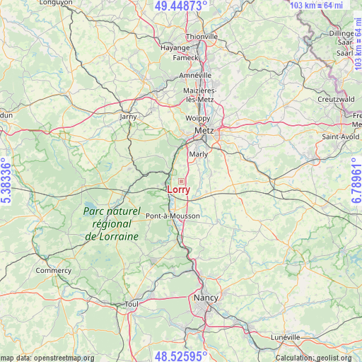
Lorry GPS coordinates[2]
48° 59' 22.128" North, 6° 5' 11.328" East
| Map corner | latitude | longitude |
|---|---|---|
| Upper-left | 49.44873°, | 5.38336° |
| Center: | 48.98948°, | 6.08648° |
| Lower-right: | 48.52595°, | 6.78961° |
| Map W x H: | 102.6×102.6 km | = 63.8×63.8mi |
| max Lat: | 51.07786° ⇑20.5% North |
| Lorry: | 48.98948° |
| min Lat: | ⇓79.5% South 41.3874° |
| min Long | Lorry | max Long |
| -5.08615° | 6.08648° | 9.52242° |
| W 88%⇐ | ⇒12% E |
Elevation
Elevation of Lorry is 231 m = 758 ft, and this is 37.3 m = 122 ft above average elevation for this country.
| Max E: |
2333 m = 7654 ft | 27.8% |
| Lorry | 231 m 758 ft | |
| Avg. | 193.7 m = 635 ft | |
Min E: |
-1 m = -3 ft | 72.2% |
See also: France elevation on elevation.city.
Geographical zone
Lorry is located in North temperate zone (between Tropic of Cancer and the Arctic Circle). Distance of this North polar circle is 1954.1 km =1214.2 mi to North.| Distance of | km | miles | from Lorry |
|---|---|---|---|
| North Pole | 4559.9 | 2833.4 | to North |
| Arctic Circle | 1954.1 | 1214.2 | to North |
| Tropic Cancer | 2841.2 | 1765.4 | to South |
| Equator | 5447.1 | 3384.7 | to South |


Nearby cities:
15 places around Lorry: (largest is in red/bold)
• Ancy-sur-Moselle
7.8 km =4.8 mi,  344°
344°
• Arnaville
4.8 km =3 mi,  300°
300°
• Cheminot
6 km =3.7 mi,  140°
140°
• Coin-lès-Cuvry
7.1 km =4.4 mi,  45°
45°
• Corny-sur-Moselle
5.5 km =3.4 mi, 339°
• Cuvry
8 km =5 mi,  41°
41°
• Féy
4.6 km =2.9 mi,  11°
11°
• Louvigny
7.8 km =4.8 mi,  112°
112°
• Marieulles
1.6 km =1 mi, 40°
• Norroy-lès-Pont-à-Mousson
7.3 km =4.5 mi,  213°
213°
• Novéant-sur-Moselle
4.7 km =2.9 mi,  323°
323°
• Pagny-sur-Moselle
4.8 km =3 mi,  262°
262°
• Pommérieux
6.4 km =4 mi,  82°
82°
• Pournoy-la-Chétive
5.9 km =3.7 mi,  56°
56°
• Vandières
5.6 km =3.5 mi,  224°
224°
Sources, notices
• [Note1] Compared only with cities in France existing in our database
• [Src1] Map data: © OpenStreetMap contributors (CC-BY-SA)
• [Src2] Other city data from geonames.org with taken over terms of usage.
• [Src3] Geographical zone / Annual Mean Temperature by Robert A. Rohde @ Wikipedia
