Orchamps geodata
Orchamps (Bourgogne-Franche-Comté) is a populated place; located in France in Europe/Paris (GMT+2) time zone. With population of 1,040 people, there are 8540 cities with bigger population in this country. Compared to other cities in France, 53.6% of cities are located further ↑North; 84.1% of cities are located further ←West and 71.4% of cities have lower elevation than Orchamps. Note1
Administrative division(s):
- Level 1: Bourgogne-Franche-Comté
- Level 2: Jura
- Level 3: Arrondissement de Dole
- Level 4: Orchamps


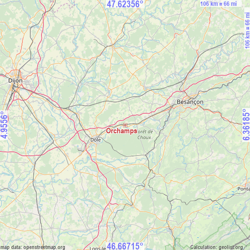
Orchamps GPS coordinates[2]
47° 8' 51.036" North, 5° 39' 31.428" East
| Map corner | latitude | longitude |
|---|---|---|
| Upper-left | 47.62356°, | 4.9556° |
| Center: | 47.14751°, | 5.65873° |
| Lower-right: | 46.66715°, | 6.36185° |
| Map W x H: | 106.3×106.3 km | = 66.1×66.1mi |
| max Lat: | 51.07786° ⇑53.6% North |
| Orchamps: | 47.14751° |
| min Lat: | ⇓46.4% South 41.3874° |
| min Long | Orchamps | max Long |
| -5.08615° | 5.65873° | 9.52242° |
| W 84.1%⇐ | ⇒15.9% E |
Elevation
Elevation of Orchamps is 226 m = 741 ft, and this is 32.3 m = 106 ft above average elevation for this country.
| Max E: |
2333 m = 7654 ft | 28.6% |
| Orchamps | 226 m 741 ft | |
| Avg. | 193.7 m = 635 ft | |
Min E: |
-1 m = -3 ft | 71.4% |
See also: France elevation on elevation.city.
Geographical zone
Orchamps is located in North temperate zone (between Tropic of Cancer and the Arctic Circle). Distance of this North polar circle is 2158.9 km =1341.5 mi to North.| Distance of | km | miles | from Orchamps |
|---|---|---|---|
| North Pole | 4764.8 | 2960.7 | to North |
| Arctic Circle | 2158.9 | 1341.5 | to North |
| Tropic Cancer | 2636.4 | 1638.2 | to South |
| Equator | 5242.3 | 3257.4 | to South |


Nearby cities:
15 places around Orchamps: (largest is in red/bold)
• Arc-et-Senans
15.4 km =9.6 mi,  146°
146°
• Authume
12.1 km =7.5 mi,  259°
259°
• Brevans
11.6 km =7.2 mi,  240°
240°
• Byans-sur-Doubs
15.3 km =9.5 mi,  103°
103°
• Dampierre
6.3 km =3.9 mi,  82°
82°
• Dole
14.2 km =8.8 mi, 244°
• Fraisans
7.7 km =4.8 mi,  89°
89°
• La Loye
15.5 km =9.6 mi,  209°
209°
• Liesle
15.1 km =9.4 mi,  129°
129°
• Moissey
11.6 km =7.2 mi,  298°
298°
• Pouilley-Français
15.6 km =9.7 mi,  65°
65°
• Rochefort-sur-Nenon
7.7 km =4.8 mi,  251°
251°
• Saint-Vit
12.6 km =7.8 mi, 71°
• Sampans
15.5 km =9.6 mi, 261°
• Évans
9 km =5.6 mi, 67°
Sources, notices
• [Note1] Compared only with cities in France existing in our database
• [Src1] Map data: © OpenStreetMap contributors (CC-BY-SA)
• [Src2] Other city data from geonames.org with taken over terms of usage.
• [Src3] Geographical zone / Annual Mean Temperature by Robert A. Rohde @ Wikipedia
