Moissey geodata
Moissey (Bourgogne-Franche-Comté) is a populated place; located in France in Europe/Paris (GMT+2) time zone. With population of 539 people, there are 14413 cities with bigger population in this country. Compared to other cities in France, 53.1% of cities are located further ↑North; 83.1% of cities are located further ←West and 73% of cities have lower elevation than Moissey. Note1
Administrative division(s):
- Level 1: Bourgogne-Franche-Comté
- Level 2: Jura
- Level 3: Arrondissement de Dole
- Level 4: Moissey


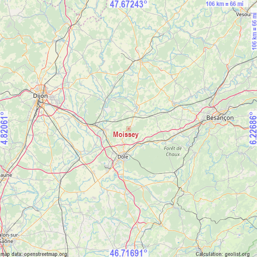
Moissey GPS coordinates[2]
47° 11' 48.552" North, 5° 31' 25.428" East
| Map corner | latitude | longitude |
|---|---|---|
| Upper-left | 47.67243°, | 4.82061° |
| Center: | 47.19682°, | 5.52373° |
| Lower-right: | 46.71691°, | 6.22686° |
| Map W x H: | 106.2×106.2 km | = 66×66mi |
| max Lat: | 51.07786° ⇑53.1% North |
| Moissey: | 47.19682° |
| min Lat: | ⇓46.9% South 41.3874° |
| min Long | Moissey | max Long |
| -5.08615° | 5.52373° | 9.52242° |
| W 83.1%⇐ | ⇒16.9% E |
Elevation
Elevation of Moissey is 236 m = 774 ft, and this is 42.3 m = 139 ft above average elevation for this country.
| Max E: |
2333 m = 7654 ft | 27% |
| Moissey | 236 m 774 ft | |
| Avg. | 193.7 m = 635 ft | |
Min E: |
-1 m = -3 ft | 73% |
See also: France elevation on elevation.city.
Geographical zone
Moissey is located in North temperate zone (between Tropic of Cancer and the Arctic Circle). Distance of this North polar circle is 2153.4 km =1338.1 mi to North.| Distance of | km | miles | from Moissey |
|---|---|---|---|
| North Pole | 4759.3 | 2957.3 | to North |
| Arctic Circle | 2153.4 | 1338.1 | to North |
| Tropic Cancer | 2641.9 | 1641.6 | to South |
| Equator | 5247.8 | 3260.8 | to South |


Nearby cities:
15 places around Moissey: (largest is in red/bold)
• Athée
12 km =7.5 mi,  287°
287°
• Authume
7.9 km =4.9 mi,  192°
192°
• Auxonne
10.3 km =6.4 mi,  267°
267°
• Brevans
11.1 km =6.9 mi,  179°
179°
• Champvans
12.1 km =7.5 mi,  212°
212°
• Dole
11.9 km =7.4 mi, 192°
• Foucherans
13.9 km =8.6 mi,  201°
201°
• Lamarche-sur-Saône
13.2 km =8.2 mi,  307°
307°
• Orchamps
11.6 km =7.2 mi,  118°
118°
• Pesmes
9.8 km =6.1 mi,  19°
19°
• Pontailler-sur-Saône
14.5 km =9 mi,  325°
325°
• Rochefort-sur-Nenon
8.5 km =5.3 mi,  160°
160°
• Sampans
9.3 km =5.8 mi, 212°
• Tillenay
13.2 km =8.2 mi,  261°
261°
• Villers-les-Pots
13.3 km =8.3 mi,  279°
279°
Sources, notices
• [Note1] Compared only with cities in France existing in our database
• [Src1] Map data: © OpenStreetMap contributors (CC-BY-SA)
• [Src2] Other city data from geonames.org with taken over terms of usage.
• [Src3] Geographical zone / Annual Mean Temperature by Robert A. Rohde @ Wikipedia
