Authume geodata
Authume (Bourgogne-Franche-Comté) is a populated place; located in France in Europe/Paris (GMT+2) time zone. With population of 800 people, there are 10613 cities with bigger population in this country. Compared to other cities in France, 53.9% of cities are located further ↑North; 82.9% of cities are located further ←West and 75.3% of cities have lower elevation than Authume. Note1
Administrative division(s):
- Level 1: Bourgogne-Franche-Comté
- Level 2: Jura
- Level 3: Arrondissement de Dole
- Level 4: Authume


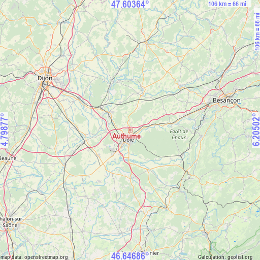
Authume GPS coordinates[2]
47° 7' 38.64" North, 5° 30' 6.804" East
| Map corner | latitude | longitude |
|---|---|---|
| Upper-left | 47.60364°, | 4.79877° |
| Center: | 47.1274°, | 5.50189° |
| Lower-right: | 46.64686°, | 6.20502° |
| Map W x H: | 106.4×106.4 km | = 66.1×66.1mi |
| max Lat: | 51.07786° ⇑53.9% North |
| Authume: | 47.1274° |
| min Lat: | ⇓46.1% South 41.3874° |
| min Long | Authume | max Long |
| -5.08615° | 5.50189° | 9.52242° |
| W 82.9%⇐ | ⇒17.1% E |
Elevation
Elevation of Authume is 251 m = 823 ft, and this is 57.3 m = 188 ft above average elevation for this country.
| Max E: |
2333 m = 7654 ft | 24.7% |
| Authume | 251 m 823 ft | |
| Avg. | 193.7 m = 635 ft | |
Min E: |
-1 m = -3 ft | 75.3% |
See also: France elevation on elevation.city.
Geographical zone
Authume is located in North temperate zone (between Tropic of Cancer and the Arctic Circle). Distance of this North polar circle is 2161.1 km =1342.8 mi to North.| Distance of | km | miles | from Authume |
|---|---|---|---|
| North Pole | 4767 | 2962.1 | to North |
| Arctic Circle | 2161.1 | 1342.8 | to North |
| Tropic Cancer | 2634.2 | 1636.8 | to South |
| Equator | 5240.1 | 3256 | to South |


Nearby cities:
15 places around Authume: (largest is in red/bold)
• Abergement-la-Ronce
11.8 km =7.3 mi,  236°
236°
• Auxonne
11.3 km =7 mi,  309°
309°
• Brevans
3.8 km =2.4 mi,  152°
152°
• Champvans
5.5 km =3.4 mi, 242°
• Choisey
7.8 km =4.8 mi,  204°
204°
• Crissey
6.8 km =4.2 mi,  191°
191°
• Damparis
8.8 km =5.5 mi,  229°
229°
• Dole
4 km =2.5 mi, 193°
• Foucherans
6.3 km =3.9 mi,  214°
214°
• Gevry
10.7 km =6.6 mi, 204°
• Moissey
7.9 km =4.9 mi,  12°
12°
• Parcey
11.8 km =7.3 mi, 185°
• Rochefort-sur-Nenon
4.6 km =2.9 mi,  93°
93°
• Sampans
3.4 km =2.1 mi,  267°
267°
• Villette-lès-Dole
9.1 km =5.7 mi,  182°
182°
Sources, notices
• [Note1] Compared only with cities in France existing in our database
• [Src1] Map data: © OpenStreetMap contributors (CC-BY-SA)
• [Src2] Other city data from geonames.org with taken over terms of usage.
• [Src3] Geographical zone / Annual Mean Temperature by Robert A. Rohde @ Wikipedia
