Onzain geodata
Onzain (Centre) is a populated place; located in France in Europe/Paris (GMT+2) time zone. With population of 3,354 people, there are 2913 cities with bigger population in this country. Compared to other cities in France, 51.2% of cities are located further ↓South; 67% of cities are located further →East and 76.2% of cities have higher elevation than Onzain. Note1
Administrative division(s):
- Level 1: Centre
- Level 2: Département du Loir-et-Cher
- Level 3: Arrondissement de Blois
- Level 4: Veuzain-sur-Loire


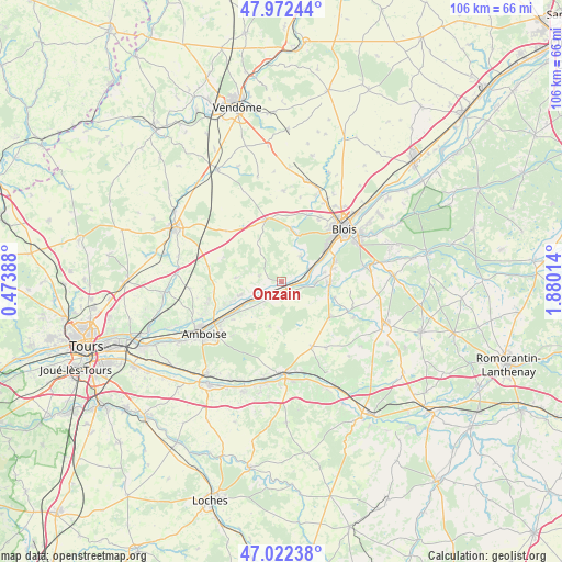
Onzain GPS coordinates[2]
47° 29' 58.416" North, 1° 10' 37.236" East
| Map corner | latitude | longitude |
|---|---|---|
| Upper-left | 47.97244°, | 0.47388° |
| Center: | 47.49956°, | 1.17701° |
| Lower-right: | 47.02238°, | 1.88014° |
| Map W x H: | 105.6×105.6 km | = 65.6×65.6mi |
| max Lat: | 51.07786° ⇑48.8% North |
| Onzain: | 47.49956° |
| min Lat: | ⇓51.2% South 41.3874° |
| min Long | Onzain | max Long |
| -5.08615° | 1.17701° | 9.52242° |
| W 33%⇐ | ⇒67% E |
Elevation
Elevation of Onzain is 64 m = 210 ft, and this is 129.7 m = 426 ft below average elevation for this country.
| Max E: |
2333 m = 7654 ft | 76.2% |
| Avg. | 193.7 m = 635 ft | |
| Onzain | 64 m = 210 ft | |
Min E: |
-1 m = -3 ft | 23.8% |
See also: France elevation on elevation.city.
Geographical zone
Onzain is located in North temperate zone (between Tropic of Cancer and the Arctic Circle). Distance of this North polar circle is 2119.7 km =1317.1 mi to North.| Distance of | km | miles | from Onzain |
|---|---|---|---|
| North Pole | 4725.6 | 2936.4 | to North |
| Arctic Circle | 2119.7 | 1317.1 | to North |
| Tropic Cancer | 2675.5 | 1662.5 | to South |
| Equator | 5281.5 | 3281.8 | to South |


Nearby cities:
15 places around Onzain: (largest is in red/bold)
• Candé-sur-Beuvron
6.2 km =3.9 mi,  94°
94°
• Cangey
9.5 km =5.9 mi,  247°
247°
• Chailles
11.2 km =7 mi,  65°
65°
• Chambon-sur-Cisse
7.6 km =4.7 mi,  22°
22°
• Chaumont-sur-Loire
2.3 km =1.4 mi,  155°
155°
• Chouzy-sur-Cisse
6 km =3.7 mi,  60°
60°
• Les Montils
9.1 km =5.7 mi, 93°
• Mesland
4.2 km =2.6 mi,  285°
285°
• Molineuf
9.1 km =5.7 mi, 19°
• Monteaux
5 km =3.1 mi, 254°
• Monthou-sur-Bièvre
9.2 km =5.7 mi,  105°
105°
• Mosnes
7.6 km =4.7 mi,  230°
230°
• Orchaise
10.3 km =6.4 mi,  9°
9°
• Ouchamps
10.3 km =6.4 mi, 106°
• Vallières-les-Grandes
8.7 km =5.4 mi,  194°
194°
Sources, notices
• [Note1] Compared only with cities in France existing in our database
• [Src1] Map data: © OpenStreetMap contributors (CC-BY-SA)
• [Src2] Other city data from geonames.org with taken over terms of usage.
• [Src3] Geographical zone / Annual Mean Temperature by Robert A. Rohde @ Wikipedia
