Mesland geodata
Mesland (Centre) is a populated place; located in France in Europe/Paris (GMT+2) time zone. With population of 541 people, there are 14367 cities with bigger population in this country. Compared to other cities in France, 51.4% of cities are located further ↓South; 67.6% of cities are located further →East and 67.4% of cities have higher elevation than Mesland. Note1
Administrative division(s):
- Level 1: Centre
- Level 2: Département du Loir-et-Cher
- Level 3: Arrondissement de Blois
- Level 4: Mesland


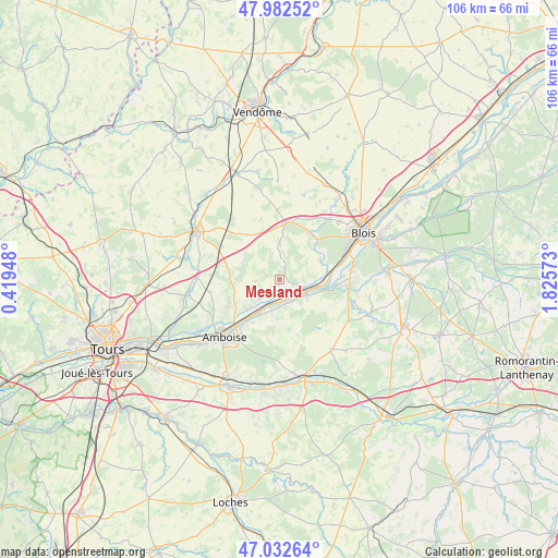
Mesland GPS coordinates[2]
47° 30' 35.028" North, 1° 7' 21.36" East
| Map corner | latitude | longitude |
|---|---|---|
| Upper-left | 47.98252°, | 0.41948° |
| Center: | 47.50973°, | 1.1226° |
| Lower-right: | 47.03264°, | 1.82573° |
| Map W x H: | 105.6×105.6 km | = 65.6×65.6mi |
| max Lat: | 51.07786° ⇑48.6% North |
| Mesland: | 47.50973° |
| min Lat: | ⇓51.4% South 41.3874° |
| min Long | Mesland | max Long |
| -5.08615° | 1.1226° | 9.52242° |
| W 32.4%⇐ | ⇒67.6% E |
Elevation
Elevation of Mesland is 84 m = 276 ft, and this is 109.7 m = 360 ft below average elevation for this country.
| Max E: |
2333 m = 7654 ft | 67.4% |
| Avg. | 193.7 m = 635 ft | |
| Mesland | 84 m = 276 ft | |
Min E: |
-1 m = -3 ft | 32.6% |
See also: France elevation on elevation.city.
Geographical zone
Mesland is located in North temperate zone (between Tropic of Cancer and the Arctic Circle). Distance of this North polar circle is 2118.6 km =1316.4 mi to North.| Distance of | km | miles | from Mesland |
|---|---|---|---|
| North Pole | 4724.5 | 2935.7 | to North |
| Arctic Circle | 2118.6 | 1316.4 | to North |
| Tropic Cancer | 2676.7 | 1663.2 | to South |
| Equator | 5282.6 | 3282.5 | to South |


Nearby cities:
15 places around Mesland: (largest is in red/bold)
• Candé-sur-Beuvron
10.4 km =6.5 mi,  99°
99°
• Cangey
6.6 km =4.1 mi,  224°
224°
• Chambon-sur-Cisse
9.1 km =5.7 mi,  49°
49°
• Chargé
11 km =6.8 mi, 218°
• Chaumont-sur-Loire
5.9 km =3.7 mi,  122°
122°
• Chouzy-sur-Cisse
9.5 km =5.9 mi,  79°
79°
• Herbault
10.7 km =6.6 mi,  6°
6°
• Limeray
8.3 km =5.2 mi,  227°
227°
• Molineuf
10.4 km =6.5 mi,  43°
43°
• Monteaux
2.6 km =1.6 mi,  196°
196°
• Mosnes
6.2 km =3.9 mi, 196°
• Onzain
4.2 km =2.6 mi,  105°
105°
• Orchaise
10.7 km =6.6 mi,  32°
32°
• Saint-Ouen-les-Vignes
10.7 km =6.6 mi,  243°
243°
• Vallières-les-Grandes
9.7 km =6 mi,  169°
169°
Sources, notices
• [Note1] Compared only with cities in France existing in our database
• [Src1] Map data: © OpenStreetMap contributors (CC-BY-SA)
• [Src2] Other city data from geonames.org with taken over terms of usage.
• [Src3] Geographical zone / Annual Mean Temperature by Robert A. Rohde @ Wikipedia
