Olmeto geodata
Olmeto (Corsica) is a populated place; located in France in Europe/Paris (GMT+1) time zone. With population of 1,176 people, there are 7669 cities with bigger population in this country. Compared to other cities in France, 99.9% of cities are located further ↑North; 99.6% of cities are located further ←West and 86% of cities have lower elevation than Olmeto. Note1
Administrative division(s):
- Level 1: Corsica
- Level 2: Département de la Corse-du-Sud
- Level 3: Arrondissement de Sartène
- Level 4: Olmeto


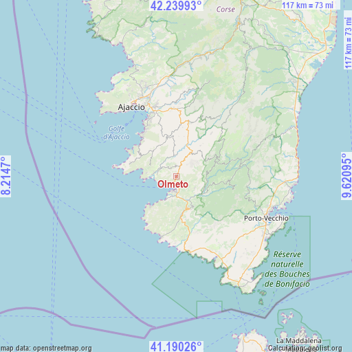
Olmeto GPS coordinates[2]
41° 43' 2.064" North, 8° 55' 4.188" East
| Map corner | latitude | longitude |
|---|---|---|
| Upper-left | 42.23993°, | 8.2147° |
| Center: | 41.71724°, | 8.91783° |
| Lower-right: | 41.19026°, | 9.62095° |
| Map W x H: | 116.7×116.7 km | = 72.5×72.5mi |
| max Lat: | 51.07786° ⇑99.9% North |
| Olmeto: | 41.71724° |
| min Lat: | ⇓0.1% South 41.3874° |
| min Long | Olmeto | max Long |
| -5.08615° | 8.91783° | 9.52242° |
| W 99.6%⇐ | ⇒0.40000000000001% E |
Elevation
Elevation of Olmeto is 360 m = 1181 ft, and this is 166.3 m = 546 ft above average elevation for this country.
| Max E: |
2333 m = 7654 ft | 14% |
| Olmeto | 360 m 1181 ft | |
| Avg. | 193.7 m = 635 ft | |
Min E: |
-1 m = -3 ft | 86% |
See also: France elevation on elevation.city.
Geographical zone
Olmeto is located in North temperate zone (between Tropic of Cancer and the Arctic Circle). Distance of this Northern Tropic circle is 2032.6 km =1263 mi to South.| Distance of | km | miles | from Olmeto |
|---|---|---|---|
| North Pole | 5368.5 | 3335.8 | to North |
| Arctic Circle | 2762.7 | 1716.7 | to North |
| Tropic Cancer | 2032.6 | 1263 | to South |
| Equator | 4638.5 | 2882.2 | to South |


Nearby cities:
15 places around Olmeto: (largest is in red/bold)
• Ajaccio
26.9 km =16.7 mi,  326°
326°
• Albitreccia
16.3 km =10.1 mi,  7°
7°
• Cauro
22.3 km =13.9 mi,  359°
359°
• Coti-Chiavari
13.6 km =8.5 mi,  296°
296°
• Cuttoli-Corticchiato
29.6 km =18.4 mi, 359°
• Grosseto-Prugna
17.5 km =10.9 mi, 12°
• Levie
17.2 km =10.7 mi,  95°
95°
• Petreto
9 km =5.6 mi,  35°
35°
• Pianottoli-Caldarello
27.3 km =17 mi,  155°
155°
• Pietrosella
14.5 km =9 mi,  335°
335°
• Propriano
4.7 km =2.9 mi,  193°
193°
• San-Gavino-di-Carbini
19.1 km =11.9 mi,  88°
88°
• Sartène
12.4 km =7.7 mi,  154°
154°
• Sotta
30.1 km =18.7 mi,  129°
129°
• Zonza
21.3 km =13.2 mi,  80°
80°
Sources, notices
• [Note1] Compared only with cities in France existing in our database
• [Src1] Map data: © OpenStreetMap contributors (CC-BY-SA)
• [Src2] Other city data from geonames.org with taken over terms of usage.
• [Src3] Geographical zone / Annual Mean Temperature by Robert A. Rohde @ Wikipedia
