Zonza geodata
Zonza (Corsica) is a populated place; located in France in Europe/Paris (GMT+2) time zone. With population of 1,888 people, there are 5054 cities with bigger population in this country. Compared to other cities in France, 99.9% of cities are located further ↑North; 99.7% of cities are located further ←West and 97.4% of cities have lower elevation than Zonza. Note1
Administrative division(s):
- Level 1: Corsica
- Level 2: Département de la Corse-du-Sud
- Level 3: Arrondissement de Sartène
- Level 4: Zonza


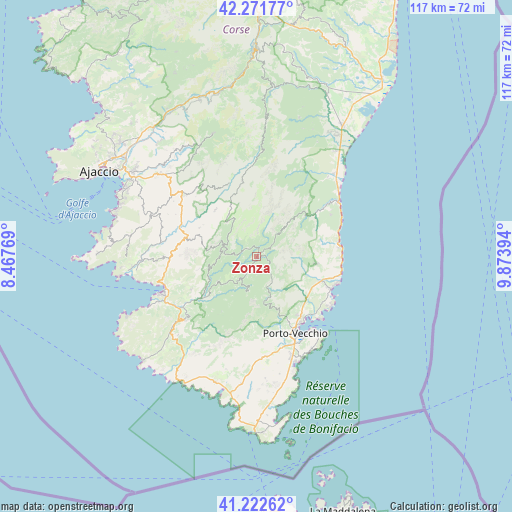
Zonza GPS coordinates[2]
41° 44' 57.624" North, 9° 10' 14.952" East
| Map corner | latitude | longitude |
|---|---|---|
| Upper-left | 42.27177°, | 8.46769° |
| Center: | 41.74934°, | 9.17082° |
| Lower-right: | 41.22262°, | 9.87394° |
| Map W x H: | 116.7×116.7 km | = 72.5×72.5mi |
| max Lat: | 51.07786° ⇑99.9% North |
| Zonza: | 41.74934° |
| min Lat: | ⇓0.1% South 41.3874° |
| min Long | Zonza | max Long |
| -5.08615° | 9.17082° | 9.52242° |
| W 99.7%⇐ | ⇒0.3% E |
Elevation
Elevation of Zonza is 761 m = 2497 ft, and this is 567.3 m = 1861 ft above average elevation for this country.
| Max E: |
2333 m = 7654 ft | 2.6% |
| Zonza | 761 m 2497 ft | |
| Avg. | 193.7 m = 635 ft | |
Min E: |
-1 m = -3 ft | 97.4% |
See also: France elevation on elevation.city.
Geographical zone
Zonza is located in North temperate zone (between Tropic of Cancer and the Arctic Circle). Distance of this Northern Tropic circle is 2036.2 km =1265.2 mi to South.| Distance of | km | miles | from Zonza |
|---|---|---|---|
| North Pole | 5365 | 3333.7 | to North |
| Arctic Circle | 2759.1 | 1714.4 | to North |
| Tropic Cancer | 2036.2 | 1265.2 | to South |
| Equator | 4642.1 | 2884.5 | to South |


Nearby cities:
15 places around Zonza: (largest is in red/bold)
• Albitreccia
22.7 km =14.1 mi,  303°
303°
• Cauro
28.3 km =17.6 mi,  311°
311°
• Conca
13.5 km =8.4 mi,  97°
97°
• Grosseto-Prugna
21.8 km =13.5 mi, 308°
• Levie
6.5 km =4 mi,  216°
216°
• Olmeto
21.3 km =13.2 mi,  260°
260°
• Petreto
16.2 km =10.1 mi,  283°
283°
• Porto-Vecchio
19.8 km =12.3 mi,  152°
152°
• Propriano
23.6 km =14.7 mi,  249°
249°
• San-Gavino-di-Carbini
3.6 km =2.2 mi,  210°
210°
• Sari-Solenzara
19.4 km =12.1 mi,  60°
60°
• Sartène
21.4 km =13.3 mi,  226°
226°
• Solaro
21.6 km =13.4 mi,  36°
36°
• Sotta
22.8 km =14.2 mi,  174°
174°
• Ventiseri
25.5 km =15.8 mi,  31°
31°
Sources, notices
• [Note1] Compared only with cities in France existing in our database
• [Src1] Map data: © OpenStreetMap contributors (CC-BY-SA)
• [Src2] Other city data from geonames.org with taken over terms of usage.
• [Src3] Geographical zone / Annual Mean Temperature by Robert A. Rohde @ Wikipedia
