Oberschaeffolsheim geodata
Oberschaeffolsheim (Grand Est) is a populated place; located in France in Europe/Paris (GMT+2) time zone. With population of 2,050 people, there are 4684 cities with bigger population in this country. Compared to other cities in France, 70.5% of cities are located further ↓South; 98.8% of cities are located further ←West and 55.3% of cities have lower elevation than Oberschaeffolsheim. Note1
Administrative division(s):
- Level 1: Grand Est
- Level 2: Bas-Rhin
- Level 3: Arrondissement de Strasbourg
- Level 4: Oberschaeffolsheim


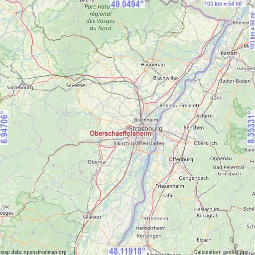
Oberschaeffolsheim GPS coordinates[2]
48° 35' 11.148" North, 7° 39' 0.648" East
| Map corner | latitude | longitude |
|---|---|---|
| Upper-left | 49.0494°, | 6.94706° |
| Center: | 48.58643°, | 7.65018° |
| Lower-right: | 48.11918°, | 8.35331° |
| Map W x H: | 103.4×103.4 km | = 64.2×64.2mi |
| max Lat: | 51.07786° ⇑29.5% North |
| Oberschaeffolsheim: | 48.58643° |
| min Lat: | ⇓70.5% South 41.3874° |
| min Long | Oberschaeffolsh | max Long |
| -5.08615° | 7.65018° | 9.52242° |
| W 98.8%⇐ | ⇒1.2% E |
Elevation
Elevation of Oberschaeffolsheim is 151 m = 495 ft, and this is 42.7 m = 140 ft below average elevation for this country.
| Max E: |
2333 m = 7654 ft | 44.7% |
| Avg. | 193.7 m = 635 ft | |
| Oberschaeffolsheim | 151 m = 495 ft | |
Min E: |
-1 m = -3 ft | 55.3% |
See also: France elevation on elevation.city.
Geographical zone
Oberschaeffolsheim is located in North temperate zone (between Tropic of Cancer and the Arctic Circle). Distance of this North polar circle is 1998.9 km =1242.1 mi to North.| Distance of | km | miles | from Oberschaeffolsheim |
|---|---|---|---|
| North Pole | 4604.8 | 2861.3 | to North |
| Arctic Circle | 1998.9 | 1242.1 | to North |
| Tropic Cancer | 2796.4 | 1737.6 | to South |
| Equator | 5402.3 | 3356.8 | to South |


Nearby cities:
15 places around Oberschaeffolsheim: (largest is in red/bold)
• Achenheim
1.7 km =1.1 mi,  248°
248°
• Breuschwickersheim
3.6 km =2.2 mi,  258°
258°
• Dingsheim
5.1 km =3.2 mi,  16°
16°
• Eckbolsheim
2.8 km =1.7 mi,  102°
102°
• Griesheim-sur-Souffel
5.7 km =3.5 mi,  14°
14°
• Hangenbieten
3.9 km =2.4 mi,  221°
221°
• Holtzheim
3.2 km =2 mi,  187°
187°
• Ittenheim
4.6 km =2.9 mi,  296°
296°
• Kolbsheim
5.3 km =3.3 mi,  237°
237°
• Lingolsheim
4 km =2.5 mi,  143°
143°
• Mittelhausbergen
4.3 km =2.7 mi,  43°
43°
• Niederhausbergen
5.7 km =3.5 mi, 42°
• Oberhausbergen
3.6 km =2.2 mi,  52°
52°
• Offenheim
5.6 km =3.5 mi,  334°
334°
• Wolfisheim
1.2 km =0.7 mi,  85°
85°
Sources, notices
• [Note1] Compared only with cities in France existing in our database
• [Src1] Map data: © OpenStreetMap contributors (CC-BY-SA)
• [Src2] Other city data from geonames.org with taken over terms of usage.
• [Src3] Geographical zone / Annual Mean Temperature by Robert A. Rohde @ Wikipedia
