Obernai geodata
Obernai (Grand Est) is a populated place; located in France in Europe/Paris (GMT+2) time zone. With population of 12,138 people, there are 792 cities with bigger population in this country. Compared to other cities in France, 67.5% of cities are located further ↓South; 97.8% of cities are located further ←West and 64.4% of cities have lower elevation than Obernai. Note1
Administrative division(s):
- Level 1: Grand Est
- Level 2: Bas-Rhin
- Level 3: Arrondissement de Sélestat-Erstein
- Level 4: Obernai


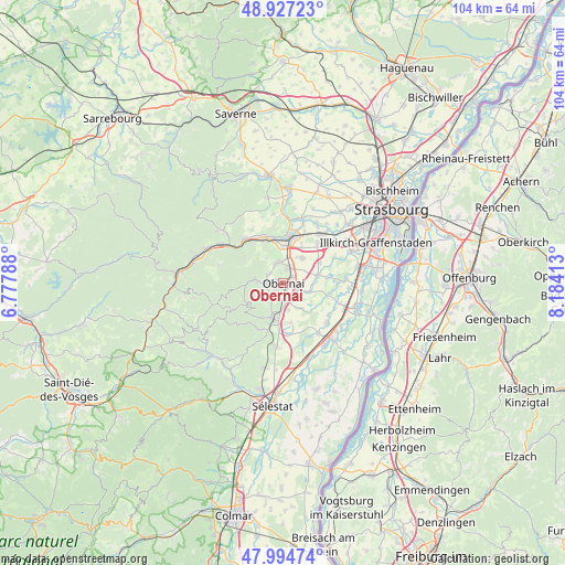
Obernai GPS coordinates[2]
48° 27' 47.268" North, 7° 28' 51.6" East
| Map corner | latitude | longitude |
|---|---|---|
| Upper-left | 48.92723°, | 6.77788° |
| Center: | 48.46313°, | 7.481° |
| Lower-right: | 47.99474°, | 8.18413° |
| Map W x H: | 103.7×103.7 km | = 64.4×64.4mi |
| max Lat: | 51.07786° ⇑32.5% North |
| Obernai: | 48.46313° |
| min Lat: | ⇓67.5% South 41.3874° |
| min Long | Obernai | max Long |
| -5.08615° | 7.481° | 9.52242° |
| W 97.8%⇐ | ⇒2.2% E |
Elevation
Elevation of Obernai is 191 m = 627 ft, and this is 2.7 m = 9 ft below average elevation for this country.
| Max E: |
2333 m = 7654 ft | 35.6% |
| Avg. | 193.7 m = 635 ft | |
| Obernai | 191 m = 627 ft | |
Min E: |
-1 m = -3 ft | 64.4% |
See also: France elevation on elevation.city.
Geographical zone
Obernai is located in North temperate zone (between Tropic of Cancer and the Arctic Circle). Distance of this North polar circle is 2012.6 km =1250.6 mi to North.| Distance of | km | miles | from Obernai |
|---|---|---|---|
| North Pole | 4618.5 | 2869.8 | to North |
| Arctic Circle | 2012.6 | 1250.6 | to North |
| Tropic Cancer | 2782.7 | 1729.1 | to South |
| Equator | 5388.6 | 3348.3 | to South |


Nearby cities:
15 places around Obernai: (largest is in red/bold)
• Bernardswiller
2 km =1.2 mi,  224°
224°
• Bischoffsheim
2.7 km =1.7 mi,  13°
13°
• Bœrsch
3.4 km =2.1 mi,  296°
296°
• Gertwiller
5.9 km =3.7 mi,  189°
189°
• Goxwiller
3.5 km =2.2 mi,  175°
175°
• Griesheim-près-Molsheim
5.7 km =3.5 mi,  39°
39°
• Heiligenstein
5.1 km =3.2 mi,  206°
206°
• Krautergersheim
6.5 km =4 mi,  76°
76°
• Meistratzheim
4.9 km =3 mi,  109°
109°
• Niedernai
2.9 km =1.8 mi,  117°
117°
• Ottrott
4.2 km =2.6 mi,  259°
259°
• Rosenwiller
5.6 km =3.5 mi,  326°
326°
• Rosheim
3.8 km =2.4 mi,  349°
349°
• Saint-Nabor
4.6 km =2.9 mi,  246°
246°
• Valff
5.5 km =3.4 mi,  147°
147°
Sources, notices
• [Note1] Compared only with cities in France existing in our database
• [Src1] Map data: © OpenStreetMap contributors (CC-BY-SA)
• [Src2] Other city data from geonames.org with taken over terms of usage.
• [Src3] Geographical zone / Annual Mean Temperature by Robert A. Rohde @ Wikipedia
