Nuaillé geodata
Nuaillé (Pays de la Loire) is a populated place; located in France in Europe/Paris (GMT+2) time zone. With population of 1,447 people, there are 6401 cities with bigger population in this country. Compared to other cities in France, 54.3% of cities are located further ↑North; 86.4% of cities are located further →East and 51.1% of cities have lower elevation than Nuaillé. Note1
Administrative division(s):
- Level 1: Pays de la Loire
- Level 2: Département de Maine-et-Loire
- Level 3: Arrondissement de Cholet
- Level 4: Nuaillé


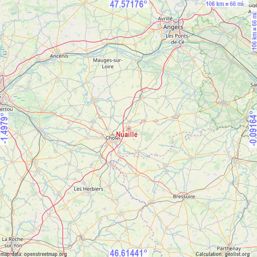
Nuaillé GPS coordinates[2]
47° 5' 42.864" North, 0° 47' 41.172" West
| Map corner | latitude | longitude |
|---|---|---|
| Upper-left | 47.57176°, | -1.4979° |
| Center: | 47.09524°, | -0.79477° |
| Lower-right: | 46.61441°, | -0.09164° |
| Map W x H: | 106.4×106.4 km | = 66.1×66.1mi |
| max Lat: | 51.07786° ⇑54.3% North |
| Nuaillé: | 47.09524° |
| min Lat: | ⇓45.7% South 41.3874° |
| min Long | Nuaillé | max Long |
| -5.08615° | -0.79477° | 9.52242° |
| W 13.6%⇐ | ⇒86.4% E |
Elevation
Elevation of Nuaillé is 136 m = 446 ft, and this is 57.7 m = 189 ft below average elevation for this country.
| Max E: |
2333 m = 7654 ft | 48.9% |
| Avg. | 193.7 m = 635 ft | |
| Nuaillé | 136 m = 446 ft | |
Min E: |
-1 m = -3 ft | 51.1% |
See also: France elevation on elevation.city.
Geographical zone
Nuaillé is located in North temperate zone (between Tropic of Cancer and the Arctic Circle). Distance of this North polar circle is 2164.7 km =1345.1 mi to North.| Distance of | km | miles | from Nuaillé |
|---|---|---|---|
| North Pole | 4770.6 | 2964.3 | to North |
| Arctic Circle | 2164.7 | 1345.1 | to North |
| Tropic Cancer | 2630.6 | 1634.6 | to South |
| Equator | 5236.5 | 3253.8 | to South |


Nearby cities:
15 places around Nuaillé: (largest is in red/bold)
• Chanteloup-les-Bois
8.4 km =5.2 mi,  90°
90°
• Cholet
7.6 km =4.7 mi,  237°
237°
• Coron
11.9 km =7.4 mi,  72°
72°
• La Jubaudière
11.3 km =7 mi,  319°
319°
• La Séguinière
11.4 km =7.1 mi,  252°
252°
• La Tessoualle
10.9 km =6.8 mi,  203°
203°
• La Tourlandry
9.2 km =5.7 mi,  53°
53°
• Le May-sur-Èvre
8.7 km =5.4 mi,  302°
302°
• Maulévrier
10.3 km =6.4 mi,  157°
157°
• Mazières-en-Mauges
5.8 km =3.6 mi, 196°
• Saint-Léger-sous-Cholet
8.7 km =5.4 mi,  269°
269°
• Toutlemonde
5 km =3.1 mi,  153°
153°
• Trémentines
3.2 km =2 mi,  13°
13°
• Vezins
7 km =4.3 mi, 66°
• Yzernay
10.7 km =6.6 mi,  139°
139°
Sources, notices
• [Note1] Compared only with cities in France existing in our database
• [Src1] Map data: © OpenStreetMap contributors (CC-BY-SA)
• [Src2] Other city data from geonames.org with taken over terms of usage.
• [Src3] Geographical zone / Annual Mean Temperature by Robert A. Rohde @ Wikipedia
