Toutlemonde geodata
Toutlemonde (Pays de la Loire) is a populated place; located in France in Europe/Paris (GMT+2) time zone. With population of 1,038 people, there are 8554 cities with bigger population in this country. Compared to other cities in France, 54.7% of cities are located further ↑North; 86.1% of cities are located further →East and 50.9% of cities have higher elevation than Toutlemonde. Note1
Administrative division(s):
- Level 1: Pays de la Loire
- Level 2: Département de Maine-et-Loire
- Level 3: Arrondissement de Cholet
- Level 4: Toutlemonde


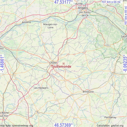
Toutlemonde GPS coordinates[2]
47° 3' 17.568" North, 0° 45' 55.728" West
| Map corner | latitude | longitude |
|---|---|---|
| Upper-left | 47.53177°, | -1.46861° |
| Center: | 47.05488°, | -0.76548° |
| Lower-right: | 46.57369°, | -0.06235° |
| Map W x H: | 106.5×106.5 km | = 66.2×66.2mi |
| max Lat: | 51.07786° ⇑54.7% North |
| Toutlemonde: | 47.05488° |
| min Lat: | ⇓45.3% South 41.3874° |
| min Long | Toutlemonde | max Long |
| -5.08615° | -0.76548° | 9.52242° |
| W 13.9%⇐ | ⇒86.1% E |
Elevation
Elevation of Toutlemonde is 129 m = 423 ft, and this is 64.7 m = 212 ft below average elevation for this country.
| Max E: |
2333 m = 7654 ft | 50.9% |
| Avg. | 193.7 m = 635 ft | |
| Toutlemonde | 129 m = 423 ft | |
Min E: |
-1 m = -3 ft | 49.1% |
See also: France elevation on elevation.city.
Geographical zone
Toutlemonde is located in North temperate zone (between Tropic of Cancer and the Arctic Circle). Distance of this North polar circle is 2169.2 km =1347.9 mi to North.| Distance of | km | miles | from Toutlemonde |
|---|---|---|---|
| North Pole | 4775 | 2967 | to North |
| Arctic Circle | 2169.2 | 1347.9 | to North |
| Tropic Cancer | 2626.1 | 1631.8 | to South |
| Equator | 5232 | 3251 | to South |


Nearby cities:
15 places around Toutlemonde: (largest is in red/bold)
• Chanteloup-les-Bois
7.6 km =4.7 mi,  54°
54°
• Cholet
8.7 km =5.4 mi,  273°
273°
• Coron
12.2 km =7.6 mi, 48°
• La Plaine
9.9 km =6.2 mi,  81°
81°
• La Tessoualle
8.6 km =5.3 mi,  229°
229°
• La Tourlandry
11.2 km =7 mi,  27°
27°
• Maulévrier
5.4 km =3.4 mi,  160°
160°
• Mazières-en-Mauges
4 km =2.5 mi,  254°
254°
• Nuaillé
5 km =3.1 mi,  333°
333°
• Saint-Léger-sous-Cholet
11.8 km =7.3 mi,  291°
291°
• Saint-Pierre-des-Échaubrognes
7.5 km =4.7 mi,  167°
167°
• Somloire
12.2 km =7.6 mi,  101°
101°
• Trémentines
7.8 km =4.8 mi,  349°
349°
• Vezins
8.4 km =5.2 mi, 30°
• Yzernay
6 km =3.7 mi,  127°
127°
Sources, notices
• [Note1] Compared only with cities in France existing in our database
• [Src1] Map data: © OpenStreetMap contributors (CC-BY-SA)
• [Src2] Other city data from geonames.org with taken over terms of usage.
• [Src3] Geographical zone / Annual Mean Temperature by Robert A. Rohde @ Wikipedia
