Noé geodata
Noé (Occitanie) is a populated place; located in France in Europe/Paris (GMT+2) time zone. With population of 2,395 people, there are 4043 cities with bigger population in this country. Compared to other cities in France, 94.7% of cities are located further ↑North; 65.8% of cities are located further →East and 66.1% of cities have lower elevation than Noé. Note1
Administrative division(s):
- Level 1: Occitanie
- Level 2: Haute-Garonne
- Level 3: Arrondissement de Muret
- Level 4: Noé


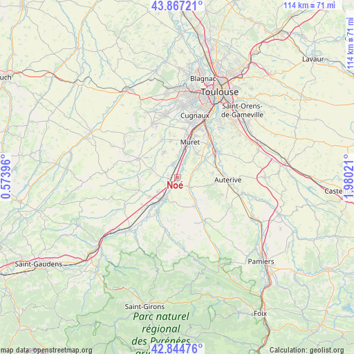
Noé GPS coordinates[2]
43° 21' 29.304" North, 1° 16' 37.524" East
| Map corner | latitude | longitude |
|---|---|---|
| Upper-left | 43.86721°, | 0.57396° |
| Center: | 43.35814°, | 1.27709° |
| Lower-right: | 42.84476°, | 1.98021° |
| Map W x H: | 113.7×113.7 km | = 70.6×70.6mi |
| max Lat: | 51.07786° ⇑94.7% North |
| Noé: | 43.35814° |
| min Lat: | ⇓5.3% South 41.3874° |
| min Long | Noé | max Long |
| -5.08615° | 1.27709° | 9.52242° |
| W 34.2%⇐ | ⇒65.8% E |
Elevation
Elevation of Noé is 199 m = 653 ft, and this is 5.3 m = 17 ft above average elevation for this country.
| Max E: |
2333 m = 7654 ft | 33.9% |
| Noé | 199 m 653 ft | |
| Avg. | 193.7 m = 635 ft | |
Min E: |
-1 m = -3 ft | 66.1% |
See also: France elevation on elevation.city.
Geographical zone
Noé is located in North temperate zone (between Tropic of Cancer and the Arctic Circle). Distance of this Northern Tropic circle is 2215.1 km =1376.4 mi to South.| Distance of | km | miles | from Noé |
|---|---|---|---|
| North Pole | 5186.1 | 3222.5 | to North |
| Arctic Circle | 2580.2 | 1603.3 | to North |
| Tropic Cancer | 2215.1 | 1376.4 | to South |
| Equator | 4821 | 2995.6 | to South |


Nearby cities:
15 places around Noé: (largest is in red/bold)
• Beaumont-sur-Lèze
7 km =4.3 mi,  68°
68°
• Bérat
8.5 km =5.3 mi,  285°
285°
• Carbonne
7.8 km =4.8 mi,  212°
212°
• Eaunes
9.3 km =5.8 mi,  41°
41°
• Lacasse
4.6 km =2.9 mi,  352°
352°
• Lavernose-Lacasse
4.5 km =2.8 mi,  344°
344°
• Le Fauga
4.5 km =2.8 mi,  19°
19°
• Lherm
9.3 km =5.8 mi,  331°
331°
• Longages
3.1 km =1.9 mi,  261°
261°
• Lézat-sur-Lèze
10.6 km =6.6 mi,  147°
147°
• Marquefave
5.1 km =3.2 mi, 208°
• Mauzac
2.2 km =1.4 mi,  34°
34°
• Poucharramet
10.7 km =6.6 mi,  307°
307°
• Saint-Hilaire
7.1 km =4.4 mi,  0°
0°
• Saint-Sulpice-sur-Lèze
4.7 km =2.9 mi,  130°
130°
Sources, notices
• [Note1] Compared only with cities in France existing in our database
• [Src1] Map data: © OpenStreetMap contributors (CC-BY-SA)
• [Src2] Other city data from geonames.org with taken over terms of usage.
• [Src3] Geographical zone / Annual Mean Temperature by Robert A. Rohde @ Wikipedia
