Lézat-sur-Lèze geodata
Lézat-sur-Lèze (Occitanie) is a populated place; located in France in Europe/Paris (GMT+2) time zone. With population of 2,233 people, there are 4304 cities with bigger population in this country. Compared to other cities in France, 96.2% of cities are located further ↑North; 65.1% of cities are located further →East and 70.4% of cities have lower elevation than Lézat-sur-Lèze. Note1
Administrative division(s):
- Level 1: Occitanie
- Level 2: Département de l'Ariège
- Level 3: Arrondissement de Saint-Girons
- Level 4: Lézat-sur-Lèze


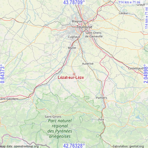
Lézat-sur-Lèze GPS coordinates[2]
43° 16' 38.424" North, 1° 20' 48.696" East
| Map corner | latitude | longitude |
|---|---|---|
| Upper-left | 43.78709°, | 0.64373° |
| Center: | 43.27734°, | 1.34686° |
| Lower-right: | 42.76328°, | 2.04998° |
| Map W x H: | 113.8×113.8 km | = 70.7×70.7mi |
| max Lat: | 51.07786° ⇑96.2% North |
| Lézat-sur-Lèze: | 43.27734° |
| min Lat: | ⇓3.8% South 41.3874° |
| min Long | Lézat-sur-Lèz | max Long |
| -5.08615° | 1.34686° | 9.52242° |
| W 34.9%⇐ | ⇒65.1% E |
Elevation
Elevation of Lézat-sur-Lèze is 221 m = 725 ft, and this is 27.3 m = 90 ft above average elevation for this country.
| Max E: |
2333 m = 7654 ft | 29.6% |
| Lézat-sur-Lèze | 221 m 725 ft | |
| Avg. | 193.7 m = 635 ft | |
Min E: |
-1 m = -3 ft | 70.4% |
See also: France elevation on elevation.city.
Geographical zone
Lézat-sur-Lèze is located in North temperate zone (between Tropic of Cancer and the Arctic Circle). Distance of this Northern Tropic circle is 2206.1 km =1370.8 mi to South.| Distance of | km | miles | from Lézat-sur-Lèze |
|---|---|---|---|
| North Pole | 5195.1 | 3228.1 | to North |
| Arctic Circle | 2589.2 | 1608.9 | to North |
| Tropic Cancer | 2206.1 | 1370.8 | to South |
| Equator | 4812 | 2990 | to South |


Nearby cities:
15 places around Lézat-sur-Lèze: (largest is in red/bold)
• Auterive
13.4 km =8.3 mi,  52°
52°
• Beaumont-sur-Lèze
11.6 km =7.2 mi,  4°
4°
• Carbonne
10.1 km =6.3 mi,  283°
283°
• Gaillac-Toulza
10.4 km =6.5 mi,  103°
103°
• Le Fauga
13.8 km =8.6 mi,  342°
342°
• Le Fossat
12.5 km =7.8 mi,  156°
156°
• Longages
12.2 km =7.6 mi,  314°
314°
• Marquefave
9.3 km =5.8 mi,  298°
298°
• Mauzac
11.7 km =7.3 mi, 337°
• Miremont
11.8 km =7.3 mi,  28°
28°
• Montesquieu-Volvestre
12.3 km =7.6 mi,  230°
230°
• Noé
10.6 km =6.6 mi,  327°
327°
• Rieux-Volvestre
12.3 km =7.6 mi,  255°
255°
• Saint-Sulpice-sur-Lèze
6.3 km =3.9 mi, 340°
• Saint-Ybars
5.5 km =3.4 mi,  144°
144°
Sources, notices
• [Note1] Compared only with cities in France existing in our database
• [Src1] Map data: © OpenStreetMap contributors (CC-BY-SA)
• [Src2] Other city data from geonames.org with taken over terms of usage.
• [Src3] Geographical zone / Annual Mean Temperature by Robert A. Rohde @ Wikipedia
