Eaunes geodata
Eaunes (Occitanie) is a populated place; located in France in Europe/Paris (GMT+2) time zone. With population of 3,831 people, there are 2566 cities with bigger population in this country. Compared to other cities in France, 94% of cities are located further ↑North; 65% of cities are located further →East and 69.2% of cities have lower elevation than Eaunes. Note1
Administrative division(s):
- Level 1: Occitanie
- Level 2: Haute-Garonne
- Level 3: Arrondissement de Muret
- Level 4: Eaunes


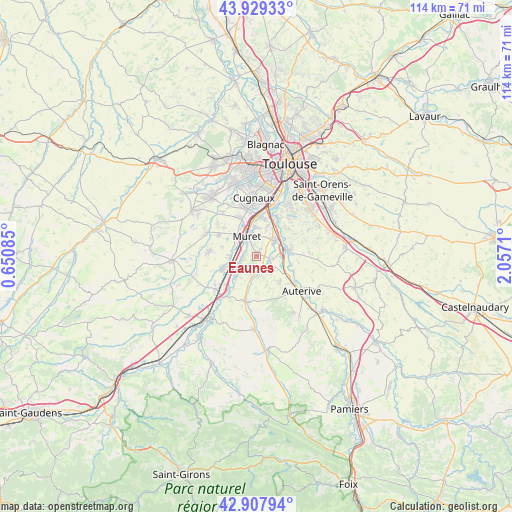
Eaunes GPS coordinates[2]
43° 25' 14.844" North, 1° 21' 14.292" East
| Map corner | latitude | longitude |
|---|---|---|
| Upper-left | 43.92933°, | 0.65085° |
| Center: | 43.42079°, | 1.35397° |
| Lower-right: | 42.90794°, | 2.0571° |
| Map W x H: | 113.6×113.6 km | = 70.6×70.6mi |
| max Lat: | 51.07786° ⇑94% North |
| Eaunes: | 43.42079° |
| min Lat: | ⇓6% South 41.3874° |
| min Long | Eaunes | max Long |
| -5.08615° | 1.35397° | 9.52242° |
| W 35%⇐ | ⇒65% E |
Elevation
Elevation of Eaunes is 215 m = 705 ft, and this is 21.3 m = 70 ft above average elevation for this country.
| Max E: |
2333 m = 7654 ft | 30.8% |
| Eaunes | 215 m 705 ft | |
| Avg. | 193.7 m = 635 ft | |
Min E: |
-1 m = -3 ft | 69.2% |
See also: France elevation on elevation.city.
Geographical zone
Eaunes is located in North temperate zone (between Tropic of Cancer and the Arctic Circle). Distance of this Northern Tropic circle is 2222 km =1380.7 mi to South.| Distance of | km | miles | from Eaunes |
|---|---|---|---|
| North Pole | 5179.1 | 3218.1 | to North |
| Arctic Circle | 2573.2 | 1598.9 | to North |
| Tropic Cancer | 2222 | 1380.7 | to South |
| Equator | 4827.9 | 2999.9 | to South |


Nearby cities:
15 places around Eaunes: (largest is in red/bold)
• Beaumont-sur-Lèze
4.4 km =2.7 mi,  175°
175°
• Clermont-le-Fort
6.6 km =4.1 mi,  54°
54°
• Grépiac
7.8 km =4.8 mi,  103°
103°
• Labarthe-sur-Lèze
5.1 km =3.2 mi, 46°
• Lacasse
7.2 km =4.5 mi,  250°
250°
• Lagardelle-sur-Lèze
3 km =1.9 mi,  110°
110°
• Lavernose-Lacasse
7.9 km =4.9 mi, 250°
• Le Fauga
5.4 km =3.4 mi,  239°
239°
• Mauzac
7.1 km =4.4 mi,  224°
224°
• Miremont
7.6 km =4.7 mi,  137°
137°
• Muret
4.9 km =3 mi,  332°
332°
• Saint-Hilaire
6.1 km =3.8 mi,  271°
271°
• Saubens
6.6 km =4.1 mi,  358°
358°
• Venerque
7.6 km =4.7 mi,  78°
78°
• Vernet
5.3 km =3.3 mi,  74°
74°
Sources, notices
• [Note1] Compared only with cities in France existing in our database
• [Src1] Map data: © OpenStreetMap contributors (CC-BY-SA)
• [Src2] Other city data from geonames.org with taken over terms of usage.
• [Src3] Geographical zone / Annual Mean Temperature by Robert A. Rohde @ Wikipedia
