Neuvy-le-Roi geodata
Neuvy-le-Roi (Centre) is a populated place; located in France in Europe/Paris (GMT+2) time zone. With population of 1,190 people, there are 7594 cities with bigger population in this country. Compared to other cities in France, 52.7% of cities are located further ↓South; 72.4% of cities are located further →East and 54.4% of cities have higher elevation than Neuvy-le-Roi. Note1
Administrative division(s):
- Level 1: Centre
- Level 2: Département d'Indre-et-Loire
- Level 3: Arrondissement de Chinon
- Level 4: Neuvy-le-Roi


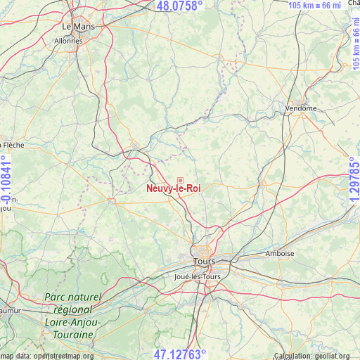
Neuvy-le-Roi GPS coordinates[2]
47° 36' 13.896" North, 0° 35' 40.992" East
| Map corner | latitude | longitude |
|---|---|---|
| Upper-left | 48.0758°, | -0.10841° |
| Center: | 47.60386°, | 0.59472° |
| Lower-right: | 47.12763°, | 1.29785° |
| Map W x H: | 105.4×105.4 km | = 65.5×65.5mi |
| max Lat: | 51.07786° ⇑47.3% North |
| Neuvy-le-Roi: | 47.60386° |
| min Lat: | ⇓52.7% South 41.3874° |
| min Long | Neuvy-le-Roi | max Long |
| -5.08615° | 0.59472° | 9.52242° |
| W 27.6%⇐ | ⇒72.4% E |
Elevation
Elevation of Neuvy-le-Roi is 118 m = 387 ft, and this is 75.7 m = 248 ft below average elevation for this country.
| Max E: |
2333 m = 7654 ft | 54.4% |
| Avg. | 193.7 m = 635 ft | |
| Neuvy-le-Roi | 118 m = 387 ft | |
Min E: |
-1 m = -3 ft | 45.6% |
See also: France elevation on elevation.city.
Geographical zone
Neuvy-le-Roi is located in North temperate zone (between Tropic of Cancer and the Arctic Circle). Distance of this North polar circle is 2108.1 km =1309.9 mi to North.| Distance of | km | miles | from Neuvy-le-Roi |
|---|---|---|---|
| North Pole | 4714 | 2929.1 | to North |
| Arctic Circle | 2108.1 | 1309.9 | to North |
| Tropic Cancer | 2687.1 | 1669.7 | to South |
| Equator | 5293.1 | 3289 | to South |


Nearby cities:
15 places around Neuvy-le-Roi: (largest is in red/bold)
• Beaumont-la-Ronce
6.8 km =4.2 mi,  124°
124°
• Cerelles
13.2 km =8.2 mi,  149°
149°
• Chemillé-sur-Dême
7.3 km =4.5 mi,  33°
33°
• Dissay-sous-Courcillon
11.4 km =7.1 mi,  306°
306°
• Les Hermites
13.7 km =8.5 mi,  60°
60°
• Marçon
13.4 km =8.3 mi,  332°
332°
• Neuillé-Pont-Pierre
7 km =4.3 mi,  208°
208°
• Nouzilly
13.1 km =8.1 mi, 119°
• Rouziers-de-Touraine
10.4 km =6.5 mi,  157°
157°
• Saint-Antoine-du-Rocher
12.2 km =7.6 mi,  167°
167°
• Saint-Christophe-sur-le-Nais
8.9 km =5.5 mi,  279°
279°
• Saint-Laurent-en-Gâtines
13.9 km =8.6 mi,  97°
97°
• Saint-Paterne-Racan
8.2 km =5.1 mi,  268°
268°
• Semblançay
11.6 km =7.2 mi,  184°
184°
• Sonzay
13.1 km =8.1 mi,  229°
229°
Sources, notices
• [Note1] Compared only with cities in France existing in our database
• [Src1] Map data: © OpenStreetMap contributors (CC-BY-SA)
• [Src2] Other city data from geonames.org with taken over terms of usage.
• [Src3] Geographical zone / Annual Mean Temperature by Robert A. Rohde @ Wikipedia
