Semblançay geodata
Semblançay (Centre) is a populated place; located in France in Europe/Paris (GMT+2) time zone. With population of 2,057 people, there are 4667 cities with bigger population in this country. Compared to other cities in France, 51.2% of cities are located further ↓South; 72.6% of cities are located further →East and 57.9% of cities have higher elevation than Semblançay. Note1
Administrative division(s):
- Level 1: Centre
- Level 2: Département d'Indre-et-Loire
- Level 3: Arrondissement de Chinon
- Level 4: Semblançay


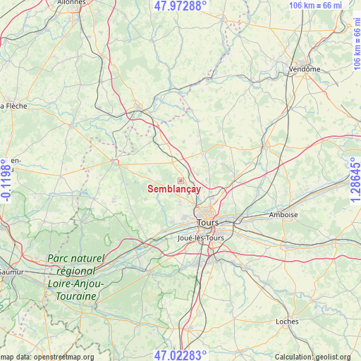
Semblançay GPS coordinates[2]
47° 30' 0" North, 0° 34' 59.988" East
| Map corner | latitude | longitude |
|---|---|---|
| Upper-left | 47.97288°, | -0.1198° |
| Center: | 47.5°, | 0.58333° |
| Lower-right: | 47.02283°, | 1.28645° |
| Map W x H: | 105.6×105.6 km | = 65.6×65.6mi |
| max Lat: | 51.07786° ⇑48.8% North |
| Semblançay: | 47.5° |
| min Lat: | ⇓51.2% South 41.3874° |
| min Long | Semblançay | max Long |
| -5.08615° | 0.58333° | 9.52242° |
| W 27.4%⇐ | ⇒72.6% E |
Elevation
Elevation of Semblançay is 108 m = 354 ft, and this is 85.7 m = 281 ft below average elevation for this country.
| Max E: |
2333 m = 7654 ft | 57.9% |
| Avg. | 193.7 m = 635 ft | |
| Semblançay | 108 m = 354 ft | |
Min E: |
-1 m = -3 ft | 42.1% |
See also: France elevation on elevation.city.
Geographical zone
Semblançay is located in North temperate zone (between Tropic of Cancer and the Arctic Circle). Distance of this North polar circle is 2119.7 km =1317.1 mi to North.| Distance of | km | miles | from Semblançay |
|---|---|---|---|
| North Pole | 4725.6 | 2936.4 | to North |
| Arctic Circle | 2119.7 | 1317.1 | to North |
| Tropic Cancer | 2675.6 | 1662.5 | to South |
| Equator | 5281.5 | 3281.8 | to South |


Nearby cities:
15 places around Semblançay: (largest is in red/bold)
• Ambillou
11.6 km =7.2 mi,  241°
241°
• Beaumont-la-Ronce
10.1 km =6.3 mi,  40°
40°
• Cerelles
7.5 km =4.7 mi,  88°
88°
• Chanceaux-sur-Choisille
9.7 km =6 mi,  109°
109°
• Charentilly
3.9 km =2.4 mi,  150°
150°
• Fondettes
10.8 km =6.7 mi,  174°
174°
• La Membrolle-sur-Choisille
7.9 km =4.9 mi, 152°
• Mettray
7.2 km =4.5 mi,  136°
136°
• Neuillé-Pont-Pierre
5.9 km =3.7 mi,  334°
334°
• Neuvy-le-Roi
11.6 km =7.2 mi,  4°
4°
• Pernay
8.9 km =5.5 mi,  224°
224°
• Rouziers-de-Touraine
5.3 km =3.3 mi,  68°
68°
• Saint-Antoine-du-Rocher
3.5 km =2.2 mi,  95°
95°
• Saint-Roch
6.4 km =4 mi,  178°
178°
• Sonzay
9.6 km =6 mi,  288°
288°
Sources, notices
• [Note1] Compared only with cities in France existing in our database
• [Src1] Map data: © OpenStreetMap contributors (CC-BY-SA)
• [Src2] Other city data from geonames.org with taken over terms of usage.
• [Src3] Geographical zone / Annual Mean Temperature by Robert A. Rohde @ Wikipedia
