Neuvilly geodata
Neuvilly (Hauts-de-France) is a populated place; located in France in Europe/Paris (GMT+2) time zone. With population of 973 people, there are 9041 cities with bigger population in this country. Compared to other cities in France, 94.5% of cities are located further ↓South; 64.4% of cities are located further ←West and 62.4% of cities have higher elevation than Neuvilly. Note1
Administrative division(s):
- Level 1: Hauts-de-France
- Level 2: Nord
- Level 3: Arrondissement de Cambrai
- Level 4: Neuvilly


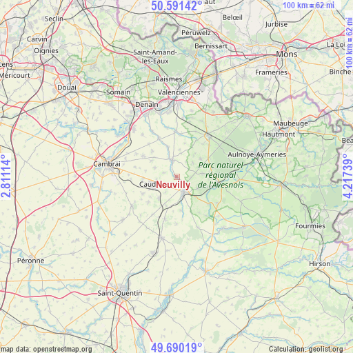
Neuvilly GPS coordinates[2]
50° 8' 34.548" North, 3° 30' 51.336" East
| Map corner | latitude | longitude |
|---|---|---|
| Upper-left | 50.59142°, | 2.81114° |
| Center: | 50.14293°, | 3.51426° |
| Lower-right: | 49.69019°, | 4.21739° |
| Map W x H: | 100.2×100.2 km | = 62.3×62.3mi |
| max Lat: | 51.07786° ⇑5.5% North |
| Neuvilly: | 50.14293° |
| min Lat: | ⇓94.5% South 41.3874° |
| min Long | Neuvilly | max Long |
| -5.08615° | 3.51426° | 9.52242° |
| W 64.4%⇐ | ⇒35.6% E |
Elevation
Elevation of Neuvilly is 96 m = 315 ft, and this is 97.7 m = 321 ft below average elevation for this country.
| Max E: |
2333 m = 7654 ft | 62.4% |
| Avg. | 193.7 m = 635 ft | |
| Neuvilly | 96 m = 315 ft | |
Min E: |
-1 m = -3 ft | 37.6% |
See also: France elevation on elevation.city.
Geographical zone
Neuvilly is located in North temperate zone (between Tropic of Cancer and the Arctic Circle). Distance of this North polar circle is 1825.8 km =1134.5 mi to North.| Distance of | km | miles | from Neuvilly |
|---|---|---|---|
| North Pole | 4431.7 | 2753.7 | to North |
| Arctic Circle | 1825.8 | 1134.5 | to North |
| Tropic Cancer | 2969.5 | 1845.2 | to South |
| Equator | 5575.4 | 3464.4 | to South |


Nearby cities:
15 places around Neuvilly: (largest is in red/bold)
• Bazuel
8 km =5 mi,  136°
136°
• Bertry
8 km =5 mi,  219°
219°
• Bousies
7.4 km =4.6 mi,  83°
83°
• Briastre
2.9 km =1.8 mi,  314°
314°
• Béthencourt
5.8 km =3.6 mi,  262°
262°
• Caudry
7.6 km =4.7 mi,  254°
254°
• Forest-en-Cambrésis
4.2 km =2.6 mi,  94°
94°
• Inchy
4.2 km =2.6 mi,  237°
237°
• Pommereuil
6.8 km =4.2 mi,  120°
120°
• Quiévy
6.7 km =4.2 mi,  294°
294°
• Saint-Python
5.8 km =3.6 mi,  335°
335°
• Solesmes
4.8 km =3 mi,  345°
345°
• Troisvilles
5.3 km =3.3 mi, 216°
• Vertain
7.7 km =4.8 mi,  5°
5°
• Viesly
3.9 km =2.4 mi, 287°
Sources, notices
• [Note1] Compared only with cities in France existing in our database
• [Src1] Map data: © OpenStreetMap contributors (CC-BY-SA)
• [Src2] Other city data from geonames.org with taken over terms of usage.
• [Src3] Geographical zone / Annual Mean Temperature by Robert A. Rohde @ Wikipedia
