Briastre geodata
Briastre (Hauts-de-France) is a populated place; located in France in Europe/Paris (GMT+2) time zone. With population of 630 people, there are 12819 cities with bigger population in this country. Compared to other cities in France, 94.6% of cities are located further ↓South; 64.1% of cities are located further ←West and 68.7% of cities have higher elevation than Briastre. Note1
Administrative division(s):
- Level 1: Hauts-de-France
- Level 2: Nord
- Level 3: Arrondissement de Cambrai
- Level 4: Briastre


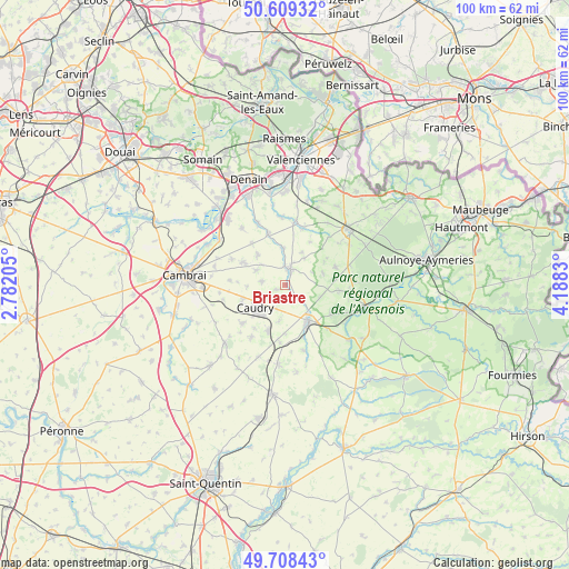
Briastre GPS coordinates[2]
50° 9' 39.6" North, 3° 29' 6.648" East
| Map corner | latitude | longitude |
|---|---|---|
| Upper-left | 50.60932°, | 2.78205° |
| Center: | 50.161°, | 3.48518° |
| Lower-right: | 49.70843°, | 4.1883° |
| Map W x H: | 100.2×100.2 km | = 62.3×62.3mi |
| max Lat: | 51.07786° ⇑5.4% North |
| Briastre: | 50.161° |
| min Lat: | ⇓94.6% South 41.3874° |
| min Long | Briastre | max Long |
| -5.08615° | 3.48518° | 9.52242° |
| W 64.1%⇐ | ⇒35.9% E |
Elevation
Elevation of Briastre is 81 m = 266 ft, and this is 112.7 m = 370 ft below average elevation for this country.
| Max E: |
2333 m = 7654 ft | 68.7% |
| Avg. | 193.7 m = 635 ft | |
| Briastre | 81 m = 266 ft | |
Min E: |
-1 m = -3 ft | 31.3% |
See also: France elevation on elevation.city.
Geographical zone
Briastre is located in North temperate zone (between Tropic of Cancer and the Arctic Circle). Distance of this North polar circle is 1823.8 km =1133.3 mi to North.| Distance of | km | miles | from Briastre |
|---|---|---|---|
| North Pole | 4429.7 | 2752.5 | to North |
| Arctic Circle | 1823.8 | 1133.3 | to North |
| Tropic Cancer | 2971.5 | 1846.4 | to South |
| Equator | 5577.4 | 3465.6 | to South |


Nearby cities:
15 places around Briastre: (largest is in red/bold)
• Béthencourt
4.6 km =2.9 mi,  233°
233°
• Bévillers
6.8 km =4.2 mi,  266°
266°
• Caudry
6.6 km =4.1 mi, 232°
• Forest-en-Cambrésis
6.7 km =4.2 mi,  110°
110°
• Haussy
6.4 km =4 mi,  354°
354°
• Inchy
4.5 km =2.8 mi,  199°
199°
• Neuvilly
2.9 km =1.8 mi,  134°
134°
• Quiévy
4.1 km =2.5 mi,  280°
280°
• Saint-Hilaire-lez-Cambrai
5.7 km =3.5 mi,  296°
296°
• Saint-Python
3.2 km =2 mi, 353°
• Saint-Vaast-en-Cambrésis
6.5 km =4 mi,  311°
311°
• Solesmes
2.8 km =1.7 mi,  19°
19°
• Troisvilles
6.3 km =3.9 mi,  189°
189°
• Vertain
6.4 km =4 mi,  26°
26°
• Viesly
1.8 km =1.1 mi,  242°
242°
Sources, notices
• [Note1] Compared only with cities in France existing in our database
• [Src1] Map data: © OpenStreetMap contributors (CC-BY-SA)
• [Src2] Other city data from geonames.org with taken over terms of usage.
• [Src3] Geographical zone / Annual Mean Temperature by Robert A. Rohde @ Wikipedia
