Moyeuvre-Grande geodata
Moyeuvre-Grande (Grand Est) is a populated place; located in France in Europe/Paris (GMT+2) time zone. With population of 9,099 people, there are 1060 cities with bigger population in this country. Compared to other cities in France, 85.2% of cities are located further ↓South; 87.6% of cities are located further ←West and 70.6% of cities have lower elevation than Moyeuvre-Grande. Note1
Administrative division(s):
- Level 1: Grand Est
- Level 2: Moselle
- Level 3: Arrondissement de Thionville
- Level 4: Moyeuvre-Grande


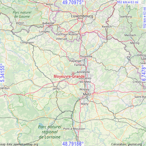
Moyeuvre-Grande GPS coordinates[2]
49° 15' 10.584" North, 6° 2' 40.812" East
| Map corner | latitude | longitude |
|---|---|---|
| Upper-left | 49.70975°, | 5.34155° |
| Center: | 49.25294°, | 6.04467° |
| Lower-right: | 48.79186°, | 6.7478° |
| Map W x H: | 102.1×102.1 km | = 63.4×63.4mi |
| max Lat: | 51.07786° ⇑14.8% North |
| Moyeuvre-Grande: | 49.25294° |
| min Lat: | ⇓85.2% South 41.3874° |
| min Long | Moyeuvre-Grande | max Long |
| -5.08615° | 6.04467° | 9.52242° |
| W 87.6%⇐ | ⇒12.4% E |
Elevation
Elevation of Moyeuvre-Grande is 222 m = 728 ft, and this is 28.3 m = 93 ft above average elevation for this country.
| Max E: |
2333 m = 7654 ft | 29.4% |
| Moyeuvre-Grande | 222 m 728 ft | |
| Avg. | 193.7 m = 635 ft | |
Min E: |
-1 m = -3 ft | 70.6% |
See also: France elevation on elevation.city.
Geographical zone
Moyeuvre-Grande is located in North temperate zone (between Tropic of Cancer and the Arctic Circle). Distance of this North polar circle is 1924.8 km =1196 mi to North.| Distance of | km | miles | from Moyeuvre-Grande |
|---|---|---|---|
| North Pole | 4530.6 | 2815.2 | to North |
| Arctic Circle | 1924.8 | 1196 | to North |
| Tropic Cancer | 2870.5 | 1783.6 | to South |
| Equator | 5476.4 | 3402.9 | to South |


Nearby cities:
15 places around Moyeuvre-Grande: (largest is in red/bold)
• Amnéville
6.5 km =4 mi,  86°
86°
• Clouange
4 km =2.5 mi,  74°
74°
• Gandrange
6.2 km =3.9 mi, 70°
• Homécourt
5.2 km =3.2 mi,  226°
226°
• Jœuf
3 km =1.9 mi,  222°
222°
• Marange-Silvange
6.6 km =4.1 mi,  138°
138°
• Montois-la-Montagne
4.4 km =2.7 mi,  202°
202°
• Moutiers
6.2 km =3.9 mi,  248°
248°
• Moyeuvre-Petite
2.4 km =1.5 mi,  323°
323°
• Pierrevillers
5.3 km =3.3 mi,  126°
126°
• Ranguevaux
5 km =3.1 mi,  8°
8°
• Rombas
3.6 km =2.2 mi,  96°
96°
• Roncourt
5.6 km =3.5 mi,  183°
183°
• Rosselange
1.8 km =1.1 mi, 72°
• Vitry-sur-Orne
5 km =3.1 mi, 73°
Sources, notices
• [Note1] Compared only with cities in France existing in our database
• [Src1] Map data: © OpenStreetMap contributors (CC-BY-SA)
• [Src2] Other city data from geonames.org with taken over terms of usage.
• [Src3] Geographical zone / Annual Mean Temperature by Robert A. Rohde @ Wikipedia
