Jœuf geodata
Jœuf (Grand Est) is a populated place; located in France in Europe/Paris (GMT+2) time zone. With population of 7,064 people, there are 1380 cities with bigger population in this country. Compared to other cities in France, 84.9% of cities are located further ↓South; 87.2% of cities are located further ←West and 65.2% of cities have lower elevation than Jœuf. Note1
Administrative division(s):
- Level 1: Grand Est
- Level 2: Meurthe-et-Moselle
- Level 3: Arrondissement de Briey
- Level 4: Jœuf


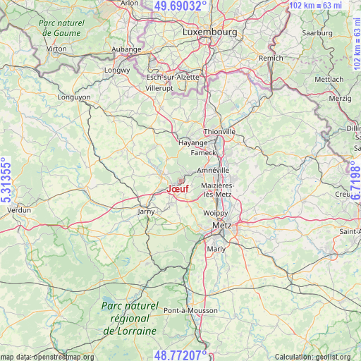
Jœuf GPS coordinates[2]
49° 13' 59.988" North, 6° 1' 0.012" East
| Map corner | latitude | longitude |
|---|---|---|
| Upper-left | 49.69032°, | 5.31355° |
| Center: | 49.23333°, | 6.01667° |
| Lower-right: | 48.77207°, | 6.7198° |
| Map W x H: | 102.1×102.1 km | = 63.4×63.4mi |
| max Lat: | 51.07786° ⇑15.1% North |
| Jœuf: | 49.23333° |
| min Lat: | ⇓84.9% South 41.3874° |
| min Long | Jœuf | max Long |
| -5.08615° | 6.01667° | 9.52242° |
| W 87.2%⇐ | ⇒12.8% E |
Elevation
Elevation of Jœuf is 195 m = 640 ft, and this is 1.3 m = 4 ft above average elevation for this country.
| Max E: |
2333 m = 7654 ft | 34.8% |
| Jœuf | 195 m 640 ft | |
| Avg. | 193.7 m = 635 ft | |
Min E: |
-1 m = -3 ft | 65.2% |
See also: France elevation on elevation.city.
Geographical zone
Jœuf is located in North temperate zone (between Tropic of Cancer and the Arctic Circle). Distance of this North polar circle is 1926.9 km =1197.3 mi to North.| Distance of | km | miles | from Jœuf |
|---|---|---|---|
| North Pole | 4532.8 | 2816.6 | to North |
| Arctic Circle | 1926.9 | 1197.3 | to North |
| Tropic Cancer | 2868.3 | 1782.3 | to South |
| Equator | 5474.2 | 3401.5 | to South |


Nearby cities:
15 places around Jœuf: (largest is in red/bold)
• Auboué
3.8 km =2.4 mi,  230°
230°
• Briey
5.9 km =3.7 mi,  287°
287°
• Homécourt
2.3 km =1.4 mi, 231°
• Moineville
6.1 km =3.8 mi,  239°
239°
• Montois-la-Montagne
1.9 km =1.2 mi,  169°
169°
• Moutiers
3.7 km =2.3 mi,  269°
269°
• Moyeuvre-Grande
3 km =1.9 mi,  42°
42°
• Moyeuvre-Petite
4.1 km =2.5 mi,  8°
8°
• Pierrevillers
6.4 km =4 mi,  98°
98°
• Rombas
5.9 km =3.7 mi,  72°
72°
• Roncourt
3.8 km =2.4 mi,  153°
153°
• Rosselange
4.7 km =2.9 mi,  54°
54°
• Saint-Privat-la-Montagne
5.3 km =3.3 mi,  162°
162°
• Sainte-Marie-aux-Chênes
4.7 km =2.9 mi,  193°
193°
• Valleroy
6.4 km =4 mi,  245°
245°
Sources, notices
• [Note1] Compared only with cities in France existing in our database
• [Src1] Map data: © OpenStreetMap contributors (CC-BY-SA)
• [Src2] Other city data from geonames.org with taken over terms of usage.
• [Src3] Geographical zone / Annual Mean Temperature by Robert A. Rohde @ Wikipedia
