Pierrevillers geodata
Pierrevillers (Grand Est) is a populated place; located in France in Europe/Paris (GMT+2) time zone. With population of 1,377 people, there are 6691 cities with bigger population in this country. Compared to other cities in France, 84.7% of cities are located further ↓South; 88.2% of cities are located further ←West and 70.6% of cities have lower elevation than Pierrevillers. Note1
Administrative division(s):
- Level 1: Grand Est
- Level 2: Moselle
- Level 3: Arrondissement de Metz
- Level 4: Pierrevillers


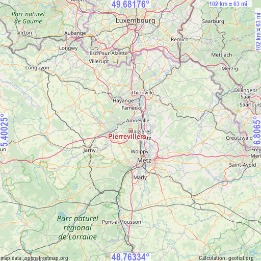
Pierrevillers GPS coordinates[2]
49° 13' 28.848" North, 6° 6' 12.132" East
| Map corner | latitude | longitude |
|---|---|---|
| Upper-left | 49.68176°, | 5.40025° |
| Center: | 49.22468°, | 6.10337° |
| Lower-right: | 48.76334°, | 6.8065° |
| Map W x H: | 102.1×102.1 km | = 63.4×63.4mi |
| max Lat: | 51.07786° ⇑15.3% North |
| Pierrevillers: | 49.22468° |
| min Lat: | ⇓84.7% South 41.3874° |
| min Long | Pierrevillers | max Long |
| -5.08615° | 6.10337° | 9.52242° |
| W 88.2%⇐ | ⇒11.8% E |
Elevation
Elevation of Pierrevillers is 222 m = 728 ft, and this is 28.3 m = 93 ft above average elevation for this country.
| Max E: |
2333 m = 7654 ft | 29.4% |
| Pierrevillers | 222 m 728 ft | |
| Avg. | 193.7 m = 635 ft | |
Min E: |
-1 m = -3 ft | 70.6% |
See also: France elevation on elevation.city.
Geographical zone
Pierrevillers is located in North temperate zone (between Tropic of Cancer and the Arctic Circle). Distance of this North polar circle is 1927.9 km =1197.9 mi to North.| Distance of | km | miles | from Pierrevillers |
|---|---|---|---|
| North Pole | 4533.8 | 2817.2 | to North |
| Arctic Circle | 1927.9 | 1197.9 | to North |
| Tropic Cancer | 2867.4 | 1781.7 | to South |
| Equator | 5473.3 | 3400.9 | to South |


Nearby cities:
15 places around Pierrevillers: (largest is in red/bold)
• Amnéville
4.2 km =2.6 mi,  32°
32°
• Bronvaux
3.4 km =2.1 mi,  200°
200°
• Clouange
4.2 km =2.6 mi,  353°
353°
• Fèves
3.4 km =2.1 mi,  163°
163°
• Hagondange
5.1 km =3.2 mi,  58°
58°
• Maizières-lès-Metz
4.3 km =2.7 mi,  107°
107°
• Marange-Silvange
1.8 km =1.1 mi,  177°
177°
• Moyeuvre-Grande
5.3 km =3.3 mi,  306°
306°
• Norroy-le-Veneur
4.8 km =3 mi, 179°
• Rombas
2.8 km =1.7 mi, 346°
• Roncourt
5.2 km =3.2 mi,  241°
241°
• Rosselange
4.5 km =2.8 mi,  325°
325°
• Semécourt
4.2 km =2.6 mi,  143°
143°
• Talange
5.1 km =3.2 mi,  76°
76°
• Vitry-sur-Orne
4.6 km =2.9 mi,  6°
6°
Sources, notices
• [Note1] Compared only with cities in France existing in our database
• [Src1] Map data: © OpenStreetMap contributors (CC-BY-SA)
• [Src2] Other city data from geonames.org with taken over terms of usage.
• [Src3] Geographical zone / Annual Mean Temperature by Robert A. Rohde @ Wikipedia
