Gandrange geodata
Gandrange (Grand Est) is a populated place; located in France in Europe/Paris (GMT+2) time zone. With population of 2,502 people, there are 3892 cities with bigger population in this country. Compared to other cities in France, 85.5% of cities are located further ↓South; 88.5% of cities are located further ←West and 61.3% of cities have lower elevation than Gandrange. Note1
Administrative division(s):
- Level 1: Grand Est
- Level 2: Moselle
- Level 3: Arrondissement de Thionville
- Level 4: Gandrange


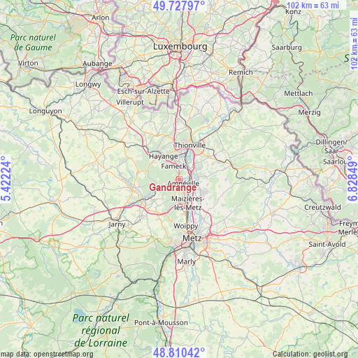
Gandrange GPS coordinates[2]
49° 16' 16.788" North, 6° 7' 31.296" East
| Map corner | latitude | longitude |
|---|---|---|
| Upper-left | 49.72797°, | 5.42224° |
| Center: | 49.27133°, | 6.12536° |
| Lower-right: | 48.81042°, | 6.82849° |
| Map W x H: | 102×102 km | = 63.4×63.4mi |
| max Lat: | 51.07786° ⇑14.5% North |
| Gandrange: | 49.27133° |
| min Lat: | ⇓85.5% South 41.3874° |
| min Long | Gandrange | max Long |
| -5.08615° | 6.12536° | 9.52242° |
| W 88.5%⇐ | ⇒11.5% E |
Elevation
Elevation of Gandrange is 176 m = 577 ft, and this is 17.7 m = 58 ft below average elevation for this country.
| Max E: |
2333 m = 7654 ft | 38.7% |
| Avg. | 193.7 m = 635 ft | |
| Gandrange | 176 m = 577 ft | |
Min E: |
-1 m = -3 ft | 61.3% |
See also: France elevation on elevation.city.
Geographical zone
Gandrange is located in North temperate zone (between Tropic of Cancer and the Arctic Circle). Distance of this North polar circle is 1922.7 km =1194.7 mi to North.| Distance of | km | miles | from Gandrange |
|---|---|---|---|
| North Pole | 4528.6 | 2813.9 | to North |
| Arctic Circle | 1922.7 | 1194.7 | to North |
| Tropic Cancer | 2872.5 | 1784.9 | to South |
| Equator | 5478.5 | 3404.2 | to South |


Nearby cities:
15 places around Gandrange: (largest is in red/bold)
• Amnéville
1.7 km =1.1 mi,  158°
158°
• Bousse
5.2 km =3.2 mi,  82°
82°
• Clouange
2.3 km =1.4 mi,  244°
244°
• Fameck
3.3 km =2.1 mi,  339°
339°
• Florange
5.8 km =3.6 mi,  357°
357°
• Hagondange
3.7 km =2.3 mi,  131°
131°
• Mondelange
3.1 km =1.9 mi,  110°
110°
• Pierrevillers
5.4 km =3.4 mi,  197°
197°
• Ranguevaux
5.9 km =3.7 mi,  299°
299°
• Richemont
2.9 km =1.8 mi, 76°
• Rombas
3.3 km =2.1 mi,  223°
223°
• Rosselange
4.4 km =2.7 mi,  249°
249°
• Talange
5.2 km =3.2 mi,  139°
139°
• Uckange
3.9 km =2.4 mi,  26°
26°
• Vitry-sur-Orne
1.2 km =0.7 mi, 240°
Sources, notices
• [Note1] Compared only with cities in France existing in our database
• [Src1] Map data: © OpenStreetMap contributors (CC-BY-SA)
• [Src2] Other city data from geonames.org with taken over terms of usage.
• [Src3] Geographical zone / Annual Mean Temperature by Robert A. Rohde @ Wikipedia
