Moye geodata
Moye (Auvergne-Rhône-Alpes) is a populated place; located in France in Europe/Paris (GMT+2) time zone. With population of 1,022 people, there are 8674 cities with bigger population in this country. Compared to other cities in France, 68.1% of cities are located further ↑North; 86.1% of cities are located further ←West and 91.7% of cities have lower elevation than Moye. Note1
Administrative division(s):
- Level 1: Auvergne-Rhône-Alpes
- Level 2: Haute-Savoie
- Level 3: Annecy
- Level 4: Moye


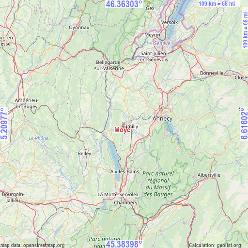
Moye GPS coordinates[2]
45° 52' 32.376" North, 5° 54' 46.404" East
| Map corner | latitude | longitude |
|---|---|---|
| Upper-left | 46.36303°, | 5.20977° |
| Center: | 45.87566°, | 5.91289° |
| Lower-right: | 45.38398°, | 6.61602° |
| Map W x H: | 108.9×108.9 km | = 67.7×67.7mi |
| max Lat: | 51.07786° ⇑68.1% North |
| Moye: | 45.87566° |
| min Lat: | ⇓31.9% South 41.3874° |
| min Long | Moye | max Long |
| -5.08615° | 5.91289° | 9.52242° |
| W 86.1%⇐ | ⇒13.9% E |
Elevation
Elevation of Moye is 467 m = 1532 ft, and this is 273.3 m = 897 ft above average elevation for this country.
| Max E: |
2333 m = 7654 ft | 8.3% |
| Moye | 467 m 1532 ft | |
| Avg. | 193.7 m = 635 ft | |
Min E: |
-1 m = -3 ft | 91.7% |
See also: France elevation on elevation.city.
Geographical zone
Moye is located in North temperate zone (between Tropic of Cancer and the Arctic Circle). Distance of this North polar circle is 2300.3 km =1429.3 mi to North.| Distance of | km | miles | from Moye |
|---|---|---|---|
| North Pole | 4906.2 | 3048.6 | to North |
| Arctic Circle | 2300.3 | 1429.3 | to North |
| Tropic Cancer | 2495 | 1550.3 | to South |
| Equator | 5100.9 | 3169.6 | to South |


Nearby cities:
15 places around Moye: (largest is in red/bold)
• Anglefort
9 km =5.6 mi,  296°
296°
• Chindrieux
7.9 km =4.9 mi,  217°
217°
• Hauteville-sur-Fier
5.6 km =3.5 mi,  55°
55°
• Marcellaz-Albanais
6.7 km =4.2 mi,  90°
90°
• Marigny-Saint-Marcel
7.3 km =4.5 mi,  133°
133°
• Massingy
5.2 km =3.2 mi,  174°
174°
• Ruffieux
6.1 km =3.8 mi,  241°
241°
• Rumilly
3 km =1.9 mi,  122°
122°
• Sales
3.6 km =2.2 mi, 92°
• Serrières-en-Chautagne
5.4 km =3.4 mi,  277°
277°
• Thusy
8.4 km =5.2 mi,  21°
21°
• Vallières
3.4 km =2.1 mi,  35°
35°
• Vaulx
8.8 km =5.5 mi,  46°
46°
• Versonnex
6 km =3.7 mi,  9°
9°
• Étercy
7.5 km =4.7 mi,  75°
75°
Sources, notices
• [Note1] Compared only with cities in France existing in our database
• [Src1] Map data: © OpenStreetMap contributors (CC-BY-SA)
• [Src2] Other city data from geonames.org with taken over terms of usage.
• [Src3] Geographical zone / Annual Mean Temperature by Robert A. Rohde @ Wikipedia
