Chindrieux geodata
Chindrieux (Auvergne-Rhône-Alpes) is a populated place; located in France in Europe/Paris (GMT+2) time zone. With population of 1,190 people, there are 7594 cities with bigger population in this country. Compared to other cities in France, 69% of cities are located further ↑North; 85.6% of cities are located further ←West and 96.7% of cities have lower elevation than Chindrieux. Note1
Administrative division(s):
- Level 1: Auvergne-Rhône-Alpes
- Level 2: Savoie
- Level 3: Arrondissement de Chambéry
- Level 4: Chindrieux


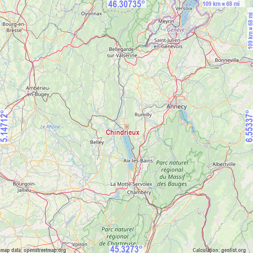
Chindrieux GPS coordinates[2]
45° 49' 10.128" North, 5° 51' 0.864" East
| Map corner | latitude | longitude |
|---|---|---|
| Upper-left | 46.30735°, | 5.14712° |
| Center: | 45.81948°, | 5.85024° |
| Lower-right: | 45.3273°, | 6.55337° |
| Map W x H: | 109×109 km | = 67.7×67.7mi |
| max Lat: | 51.07786° ⇑69% North |
| Chindrieux: | 45.81948° |
| min Lat: | ⇓31% South 41.3874° |
| min Long | Chindrieux | max Long |
| -5.08615° | 5.85024° | 9.52242° |
| W 85.6%⇐ | ⇒14.4% E |
Elevation
Elevation of Chindrieux is 698 m = 2290 ft, and this is 504.3 m = 1655 ft above average elevation for this country.
| Max E: |
2333 m = 7654 ft | 3.3% |
| Chindrieux | 698 m 2290 ft | |
| Avg. | 193.7 m = 635 ft | |
Min E: |
-1 m = -3 ft | 96.7% |
See also: France elevation on elevation.city.
Geographical zone
Chindrieux is located in North temperate zone (between Tropic of Cancer and the Arctic Circle). Distance of this North polar circle is 2306.5 km =1433.2 mi to North.| Distance of | km | miles | from Chindrieux |
|---|---|---|---|
| North Pole | 4912.4 | 3052.4 | to North |
| Arctic Circle | 2306.5 | 1433.2 | to North |
| Tropic Cancer | 2488.7 | 1546.4 | to South |
| Equator | 5094.6 | 3165.6 | to South |


Nearby cities:
15 places around Chindrieux: (largest is in red/bold)
• Albens
8.2 km =5.1 mi,  115°
115°
• Ceyzérieu
9.7 km =6 mi,  280°
280°
• Chanaz
4.5 km =2.8 mi,  254°
254°
• Châtillon
2.1 km =1.3 mi,  194°
194°
• Culoz
6 km =3.7 mi,  303°
303°
• La Biolle
9.1 km =5.7 mi,  138°
138°
• Marigny-Saint-Marcel
10.2 km =6.3 mi,  82°
82°
• Massignieu-de-Rives
9.7 km =6 mi,  222°
222°
• Massingy
5.5 km =3.4 mi, 78°
• Moye
7.9 km =4.9 mi,  37°
37°
• Ruffieux
3.3 km =2.1 mi,  350°
350°
• Rumilly
8.7 km =5.4 mi,  57°
57°
• Saint-Félix
10 km =6.2 mi,  100°
100°
• Sales
10.5 km =6.5 mi,  54°
54°
• Serrières-en-Chautagne
7 km =4.3 mi,  355°
355°
Sources, notices
• [Note1] Compared only with cities in France existing in our database
• [Src1] Map data: © OpenStreetMap contributors (CC-BY-SA)
• [Src2] Other city data from geonames.org with taken over terms of usage.
• [Src3] Geographical zone / Annual Mean Temperature by Robert A. Rohde @ Wikipedia
