Mourenx geodata
Mourenx (Nouvelle-Aquitaine) is a populated place; located in France in Europe/Paris (GMT+2) time zone. With population of 8,109 people, there are 1196 cities with bigger population in this country. Compared to other cities in France, 94.5% of cities are located further ↑North; 84.5% of cities are located further →East and 56.9% of cities have higher elevation than Mourenx. Note1
Administrative division(s):
- Level 1: Nouvelle-Aquitaine
- Level 2: Département des Pyrénées-Atlantiques
- Level 3: Arrondissement de Pau
- Level 4: Mourenx


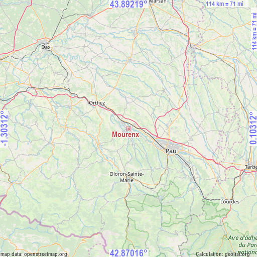
Mourenx GPS coordinates[2]
43° 22' 59.988" North, 0° 36' 0" West
| Map corner | latitude | longitude |
|---|---|---|
| Upper-left | 43.89219°, | -1.30312° |
| Center: | 43.38333°, | -0.6° |
| Lower-right: | 42.87016°, | 0.10312° |
| Map W x H: | 113.6×113.6 km | = 70.6×70.6mi |
| max Lat: | 51.07786° ⇑94.5% North |
| Mourenx: | 43.38333° |
| min Lat: | ⇓5.5% South 41.3874° |
| min Long | Mourenx | max Long |
| -5.08615° | -0.6° | 9.52242° |
| W 15.5%⇐ | ⇒84.5% E |
Elevation
Elevation of Mourenx is 111 m = 364 ft, and this is 82.7 m = 271 ft below average elevation for this country.
| Max E: |
2333 m = 7654 ft | 56.9% |
| Avg. | 193.7 m = 635 ft | |
| Mourenx | 111 m = 364 ft | |
Min E: |
-1 m = -3 ft | 43.1% |
See also: France elevation on elevation.city.
Geographical zone
Mourenx is located in North temperate zone (between Tropic of Cancer and the Arctic Circle). Distance of this Northern Tropic circle is 2217.9 km =1378.1 mi to South.| Distance of | km | miles | from Mourenx |
|---|---|---|---|
| North Pole | 5183.3 | 3220.8 | to North |
| Arctic Circle | 2577.4 | 1601.5 | to North |
| Tropic Cancer | 2217.9 | 1378.1 | to South |
| Equator | 4823.8 | 2997.4 | to South |


Nearby cities:
15 places around Mourenx: (largest is in red/bold)
• Abos
4.6 km =2.9 mi,  143°
143°
• Arbus
9.8 km =6.1 mi,  124°
124°
• Argagnon
10 km =6.2 mi,  317°
317°
• Arthez-de-Béarn
9.3 km =5.8 mi,  0°
0°
• Artix
2.7 km =1.7 mi,  56°
56°
• Aussevielle
10.1 km =6.3 mi,  111°
111°
• Denguin
8.3 km =5.2 mi,  102°
102°
• Lacq
4.6 km =2.9 mi, 324°
• Lagor
4 km =2.5 mi,  270°
270°
• Lahourcade
3.9 km =2.4 mi,  199°
199°
• Maslacq
9.8 km =6.1 mi,  304°
304°
• Monein
5.7 km =3.5 mi,  166°
166°
• Mont
6.9 km =4.3 mi, 324°
• Pardies
2.3 km =1.4 mi, 143°
• Siros
10.6 km =6.6 mi, 114°
Sources, notices
• [Note1] Compared only with cities in France existing in our database
• [Src1] Map data: © OpenStreetMap contributors (CC-BY-SA)
• [Src2] Other city data from geonames.org with taken over terms of usage.
• [Src3] Geographical zone / Annual Mean Temperature by Robert A. Rohde @ Wikipedia
