Maslacq geodata
Maslacq (Nouvelle-Aquitaine) is a populated place; located in France in Europe/Paris (GMT+2) time zone. With population of 799 people, there are 10627 cities with bigger population in this country. Compared to other cities in France, 93.9% of cities are located further ↑North; 85.5% of cities are located further →East and 68.3% of cities have higher elevation than Maslacq. Note1
Administrative division(s):
- Level 1: Nouvelle-Aquitaine
- Level 2: Département des Pyrénées-Atlantiques
- Level 3: Arrondissement de Pau
- Level 4: Maslacq


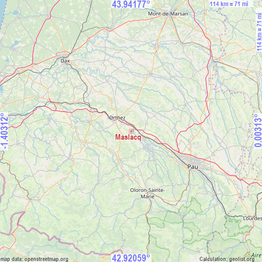
Maslacq GPS coordinates[2]
43° 25' 59.988" North, 0° 42' 0" West
| Map corner | latitude | longitude |
|---|---|---|
| Upper-left | 43.94177°, | -1.40312° |
| Center: | 43.43333°, | -0.7° |
| Lower-right: | 42.92059°, | 0.00313° |
| Map W x H: | 113.5×113.5 km | = 70.5×70.5mi |
| max Lat: | 51.07786° ⇑93.9% North |
| Maslacq: | 43.43333° |
| min Lat: | ⇓6.1% South 41.3874° |
| min Long | Maslacq | max Long |
| -5.08615° | -0.7° | 9.52242° |
| W 14.5%⇐ | ⇒85.5% E |
Elevation
Elevation of Maslacq is 82 m = 269 ft, and this is 111.7 m = 366 ft below average elevation for this country.
| Max E: |
2333 m = 7654 ft | 68.3% |
| Avg. | 193.7 m = 635 ft | |
| Maslacq | 82 m = 269 ft | |
Min E: |
-1 m = -3 ft | 31.7% |
See also: France elevation on elevation.city.
Geographical zone
Maslacq is located in North temperate zone (between Tropic of Cancer and the Arctic Circle). Distance of this Northern Tropic circle is 2223.4 km =1381.6 mi to South.| Distance of | km | miles | from Maslacq |
|---|---|---|---|
| North Pole | 5177.7 | 3217.3 | to North |
| Arctic Circle | 2571.8 | 1598 | to North |
| Tropic Cancer | 2223.4 | 1381.6 | to South |
| Equator | 4829.3 | 3000.8 | to South |


Nearby cities:
15 places around Maslacq: (largest is in red/bold)
• Argagnon
2.3 km =1.4 mi,  35°
35°
• Arthez-de-Béarn
8.9 km =5.5 mi,  65°
65°
• Artix
11.1 km =6.9 mi,  111°
111°
• Biron
4.4 km =2.7 mi,  317°
317°
• Castétis
3.9 km =2.4 mi,  340°
340°
• Lacq
5.7 km =3.5 mi, 108°
• Lagor
6.9 km =4.3 mi,  144°
144°
• Lahourcade
11.5 km =7.1 mi, 143°
• Mont
4 km =2.5 mi,  90°
90°
• Mourenx
9.8 km =6.1 mi,  124°
124°
• Navarrenx
13.3 km =8.3 mi,  201°
201°
• Orthez
8.5 km =5.3 mi, 316°
• Pardies
12 km =7.5 mi,  128°
128°
• Sallespisse
11.2 km =7 mi,  353°
353°
• Sault-de-Navailles
13.2 km =8.2 mi,  11°
11°
Sources, notices
• [Note1] Compared only with cities in France existing in our database
• [Src1] Map data: © OpenStreetMap contributors (CC-BY-SA)
• [Src2] Other city data from geonames.org with taken over terms of usage.
• [Src3] Geographical zone / Annual Mean Temperature by Robert A. Rohde @ Wikipedia
