Morieux geodata
Morieux (Brittany) is a populated place; located in France in Europe/Paris (GMT+2) time zone. With population of 803 people, there are 10571 cities with bigger population in this country. Compared to other cities in France, 68.9% of cities are located further ↓South; 96.5% of cities are located further →East and 70.1% of cities have higher elevation than Morieux. Note1
Administrative division(s):
- Level 1: Brittany
- Level 2: Département des Côtes-d’Armor
- Level 3: Arrondissement de Saint-Brieuc
- Level 4: Lamballe-Armor


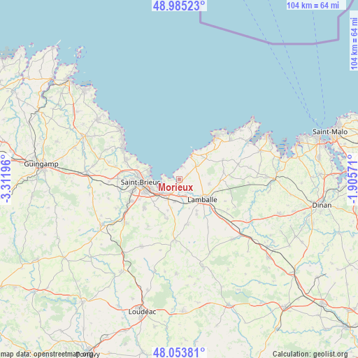
Morieux GPS coordinates[2]
48° 31' 17.976" North, 2° 36' 31.788" West
| Map corner | latitude | longitude |
|---|---|---|
| Upper-left | 48.98523°, | -3.31196° |
| Center: | 48.52166°, | -2.60883° |
| Lower-right: | 48.05381°, | -1.90571° |
| Map W x H: | 103.6×103.6 km | = 64.4×64.4mi |
| max Lat: | 51.07786° ⇑31.1% North |
| Morieux: | 48.52166° |
| min Lat: | ⇓68.9% South 41.3874° |
| min Long | Morieux | max Long |
| -5.08615° | -2.60883° | 9.52242° |
| W 3.5%⇐ | ⇒96.5% E |
Elevation
Elevation of Morieux is 78 m = 256 ft, and this is 115.7 m = 380 ft below average elevation for this country.
| Max E: |
2333 m = 7654 ft | 70.1% |
| Avg. | 193.7 m = 635 ft | |
| Morieux | 78 m = 256 ft | |
Min E: |
-1 m = -3 ft | 29.9% |
See also: France elevation on elevation.city.
Geographical zone
Morieux is located in North temperate zone (between Tropic of Cancer and the Arctic Circle). Distance of this North polar circle is 2006.1 km =1246.5 mi to North.| Distance of | km | miles | from Morieux |
|---|---|---|---|
| North Pole | 4612 | 2865.8 | to North |
| Arctic Circle | 2006.1 | 1246.5 | to North |
| Tropic Cancer | 2789.2 | 1733.1 | to South |
| Equator | 5395.1 | 3352.4 | to South |


Nearby cities:
15 places around Morieux: (largest is in red/bold)
• Andel
4.7 km =2.9 mi,  138°
138°
• Coëtmieux
3.4 km =2.1 mi,  169°
169°
• Hillion
4.3 km =2.7 mi,  259°
259°
• Lamballe
9.2 km =5.7 mi,  130°
130°
• Landéhen
11.4 km =7.1 mi,  153°
153°
• Langueux
8.6 km =5.3 mi,  249°
249°
• Meslin
9 km =5.6 mi,  161°
161°
• Noyal
12.3 km =7.6 mi, 132°
• Planguenoual
2.7 km =1.7 mi,  62°
62°
• Pléneuf-Val-André
9.2 km =5.7 mi,  29°
29°
• Pommeret
6.6 km =4.1 mi,  191°
191°
• Quessoy
11.7 km =7.3 mi,  199°
199°
• Saint-Alban
6.4 km =4 mi,  52°
52°
• Saint-Brieuc
11.8 km =7.3 mi,  266°
266°
• Yffiniac
6.5 km =4 mi,  230°
230°
Sources, notices
• [Note1] Compared only with cities in France existing in our database
• [Src1] Map data: © OpenStreetMap contributors (CC-BY-SA)
• [Src2] Other city data from geonames.org with taken over terms of usage.
• [Src3] Geographical zone / Annual Mean Temperature by Robert A. Rohde @ Wikipedia
