Coëtmieux geodata
Coëtmieux (Brittany) is a populated place; located in France in Europe/Paris (GMT+2) time zone. With population of 1,317 people, there are 6949 cities with bigger population in this country. Compared to other cities in France, 68.2% of cities are located further ↓South; 96.5% of cities are located further →East and 80.2% of cities have higher elevation than Coëtmieux. Note1
Administrative division(s):
- Level 1: Brittany
- Level 2: Département des Côtes-d’Armor
- Level 3: Arrondissement de Saint-Brieuc
- Level 4: Coëtmieux


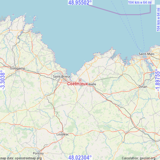
Coëtmieux GPS coordinates[2]
48° 29' 28.212" North, 2° 36' 2.412" West
| Map corner | latitude | longitude |
|---|---|---|
| Upper-left | 48.95502°, | -3.3038° |
| Center: | 48.49117°, | -2.60067° |
| Lower-right: | 48.02304°, | -1.89755° |
| Map W x H: | 103.6×103.6 km | = 64.4×64.4mi |
| max Lat: | 51.07786° ⇑31.8% North |
| Coëtmieux: | 48.49117° |
| min Lat: | ⇓68.2% South 41.3874° |
| min Long | Coëtmieux | max Long |
| -5.08615° | -2.60067° | 9.52242° |
| W 3.5%⇐ | ⇒96.5% E |
Elevation
Elevation of Coëtmieux is 54 m = 177 ft, and this is 139.7 m = 458 ft below average elevation for this country.
| Max E: |
2333 m = 7654 ft | 80.2% |
| Avg. | 193.7 m = 635 ft | |
| Coëtmieux | 54 m = 177 ft | |
Min E: |
-1 m = -3 ft | 19.8% |
See also: France elevation on elevation.city.
Geographical zone
Coëtmieux is located in North temperate zone (between Tropic of Cancer and the Arctic Circle). Distance of this North polar circle is 2009.5 km =1248.6 mi to North.| Distance of | km | miles | from Coëtmieux |
|---|---|---|---|
| North Pole | 4615.3 | 2867.8 | to North |
| Arctic Circle | 2009.5 | 1248.6 | to North |
| Tropic Cancer | 2785.8 | 1731 | to South |
| Equator | 5391.7 | 3350.2 | to South |


Nearby cities:
15 places around Coëtmieux: (largest is in red/bold)
• Andel
2.5 km =1.6 mi,  93°
93°
• Bréhand
10 km =6.2 mi,  168°
168°
• Hillion
5.5 km =3.4 mi,  297°
297°
• Lamballe
6.9 km =4.3 mi,  112°
112°
• Landéhen
8.1 km =5 mi,  146°
146°
• Langueux
8.7 km =5.4 mi,  272°
272°
• Meslin
5.6 km =3.5 mi,  155°
155°
• Morieux
3.4 km =2.1 mi,  349°
349°
• Noyal
9.8 km =6.1 mi,  120°
120°
• Planguenoual
5 km =3.1 mi,  21°
21°
• Plédran
11.9 km =7.4 mi,  244°
244°
• Pommeret
3.6 km =2.2 mi,  212°
212°
• Quessoy
8.9 km =5.5 mi, 210°
• Saint-Alban
8.5 km =5.3 mi,  31°
31°
• Yffiniac
5.6 km =3.5 mi,  262°
262°
Sources, notices
• [Note1] Compared only with cities in France existing in our database
• [Src1] Map data: © OpenStreetMap contributors (CC-BY-SA)
• [Src2] Other city data from geonames.org with taken over terms of usage.
• [Src3] Geographical zone / Annual Mean Temperature by Robert A. Rohde @ Wikipedia
