Lamballe geodata
Lamballe (Brittany) is a populated place; located in France in Europe/Paris (GMT+2) time zone. With population of 12,344 people, there are 773 cities with bigger population in this country. Compared to other cities in France, 67.6% of cities are located further ↓South; 96.3% of cities are located further →East and 81.8% of cities have higher elevation than Lamballe. Note1
Administrative division(s):
- Level 1: Brittany
- Level 2: Département des Côtes-d’Armor
- Level 3: Arrondissement de Saint-Brieuc
- Level 4: Lamballe-Armor


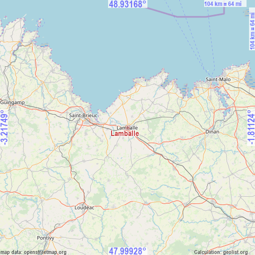
Lamballe GPS coordinates[2]
48° 28' 3.432" North, 2° 30' 51.696" West
| Map corner | latitude | longitude |
|---|---|---|
| Upper-left | 48.93168°, | -3.21749° |
| Center: | 48.46762°, | -2.51436° |
| Lower-right: | 47.99928°, | -1.81124° |
| Map W x H: | 103.7×103.7 km | = 64.4×64.4mi |
| max Lat: | 51.07786° ⇑32.4% North |
| Lamballe: | 48.46762° |
| min Lat: | ⇓67.6% South 41.3874° |
| min Long | Lamballe | max Long |
| -5.08615° | -2.51436° | 9.52242° |
| W 3.7%⇐ | ⇒96.3% E |
Elevation
Elevation of Lamballe is 50 m = 164 ft, and this is 143.7 m = 471 ft below average elevation for this country.
| Max E: |
2333 m = 7654 ft | 81.8% |
| Avg. | 193.7 m = 635 ft | |
| Lamballe | 50 m = 164 ft | |
Min E: |
-1 m = -3 ft | 18.2% |
See also: France elevation on elevation.city.
Geographical zone
Lamballe is located in North temperate zone (between Tropic of Cancer and the Arctic Circle). Distance of this North polar circle is 2012.1 km =1250.3 mi to North.| Distance of | km | miles | from Lamballe |
|---|---|---|---|
| North Pole | 4618 | 2869.5 | to North |
| Arctic Circle | 2012.1 | 1250.3 | to North |
| Tropic Cancer | 2783.2 | 1729.4 | to South |
| Equator | 5389.1 | 3348.6 | to South |


Nearby cities:
15 places around Lamballe: (largest is in red/bold)
• Andel
4.6 km =2.9 mi,  302°
302°
• Bréhand
8.4 km =5.2 mi,  211°
211°
• Coëtmieux
6.9 km =4.3 mi,  292°
292°
• Hénansal
10 km =6.2 mi,  36°
36°
• Landéhen
4.6 km =2.9 mi,  204°
204°
• Meslin
4.7 km =2.9 mi,  238°
238°
• Morieux
9.2 km =5.7 mi,  310°
310°
• Noyal
3.1 km =1.9 mi,  137°
137°
• Planguenoual
8.6 km =5.3 mi,  327°
327°
• Plestan
7 km =4.3 mi, 135°
• Plédéliac
9.9 km =6.2 mi,  101°
101°
• Pommeret
8.3 km =5.2 mi,  267°
267°
• Quessoy
11.9 km =7.4 mi, 244°
• Saint-Alban
10 km =6.2 mi,  349°
349°
• Tramain
11.1 km =6.9 mi,  131°
131°
Sources, notices
• [Note1] Compared only with cities in France existing in our database
• [Src1] Map data: © OpenStreetMap contributors (CC-BY-SA)
• [Src2] Other city data from geonames.org with taken over terms of usage.
• [Src3] Geographical zone / Annual Mean Temperature by Robert A. Rohde @ Wikipedia
