Landéhen geodata
Landéhen (Brittany) is a populated place; located in France in Europe/Paris (GMT+2) time zone. With population of 1,028 people, there are 8631 cities with bigger population in this country. Compared to other cities in France, 66.9% of cities are located further ↓South; 96.3% of cities are located further →East and 67.4% of cities have higher elevation than Landéhen. Note1
Administrative division(s):
- Level 1: Brittany
- Level 2: Département des Côtes-d’Armor
- Level 3: Arrondissement de Saint-Brieuc
- Level 4: Landéhen


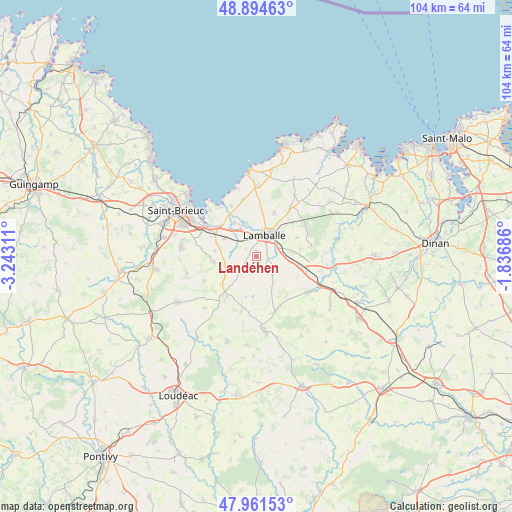
Landéhen GPS coordinates[2]
48° 25' 48.792" North, 2° 32' 23.964" West
| Map corner | latitude | longitude |
|---|---|---|
| Upper-left | 48.89463°, | -3.24311° |
| Center: | 48.43022°, | -2.53999° |
| Lower-right: | 47.96153°, | -1.83686° |
| Map W x H: | 103.8×103.7 km | = 64.5×64.4mi |
| max Lat: | 51.07786° ⇑33.1% North |
| Landéhen: | 48.43022° |
| min Lat: | ⇓66.9% South 41.3874° |
| min Long | Landéhen | max Long |
| -5.08615° | -2.53999° | 9.52242° |
| W 3.7%⇐ | ⇒96.3% E |
Elevation
Elevation of Landéhen is 84 m = 276 ft, and this is 109.7 m = 360 ft below average elevation for this country.
| Max E: |
2333 m = 7654 ft | 67.4% |
| Avg. | 193.7 m = 635 ft | |
| Landéhen | 84 m = 276 ft | |
Min E: |
-1 m = -3 ft | 32.6% |
See also: France elevation on elevation.city.
Geographical zone
Landéhen is located in North temperate zone (between Tropic of Cancer and the Arctic Circle). Distance of this North polar circle is 2016.2 km =1252.8 mi to North.| Distance of | km | miles | from Landéhen |
|---|---|---|---|
| North Pole | 4622.1 | 2872 | to North |
| Arctic Circle | 2016.2 | 1252.8 | to North |
| Tropic Cancer | 2779 | 1726.8 | to South |
| Equator | 5384.9 | 3346 | to South |


Nearby cities:
15 places around Landéhen: (largest is in red/bold)
• Andel
6.9 km =4.3 mi,  343°
343°
• Bréhand
3.9 km =2.4 mi,  220°
220°
• Coëtmieux
8.1 km =5 mi,  326°
326°
• Lamballe
4.6 km =2.9 mi,  24°
24°
• Meslin
2.7 km =1.7 mi,  307°
307°
• Moncontour
10.4 km =6.5 mi, 221°
• Morieux
11.4 km =7.1 mi, 333°
• Noyal
4.4 km =2.7 mi,  64°
64°
• Plestan
6.9 km =4.3 mi,  97°
97°
• Pommeret
7.4 km =4.6 mi,  300°
300°
• Quessoy
9 km =5.6 mi,  264°
264°
• Saint-Glen
8.1 km =5 mi,  171°
171°
• Tramain
10.7 km =6.6 mi,  107°
107°
• Trébry
8.4 km =5.2 mi,  185°
185°
• Trédaniel
9.9 km =6.2 mi, 216°
Sources, notices
• [Note1] Compared only with cities in France existing in our database
• [Src1] Map data: © OpenStreetMap contributors (CC-BY-SA)
• [Src2] Other city data from geonames.org with taken over terms of usage.
• [Src3] Geographical zone / Annual Mean Temperature by Robert A. Rohde @ Wikipedia
