Morée geodata
Morée (Centre) is a populated place; located in France in Europe/Paris (GMT+2) time zone. With population of 1,041 people, there are 8531 cities with bigger population in this country. Compared to other cities in France, 57.6% of cities are located further ↓South; 66.3% of cities are located further →East and 62% of cities have higher elevation than Morée. Note1
Administrative division(s):
- Level 1: Centre
- Level 2: Département du Loir-et-Cher
- Level 3: Arrondissement de Vendôme
- Level 4: Morée


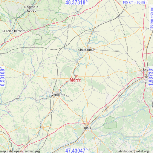
Morée GPS coordinates[2]
47° 54' 14.292" North, 1° 14' 3.156" East
| Map corner | latitude | longitude |
|---|---|---|
| Upper-left | 48.37318°, | 0.53108° |
| Center: | 47.90397°, | 1.23421° |
| Lower-right: | 47.43047°, | 1.93733° |
| Map W x H: | 104.8×104.8 km | = 65.1×65.1mi |
| max Lat: | 51.07786° ⇑42.4% North |
| Morée: | 47.90397° |
| min Lat: | ⇓57.6% South 41.3874° |
| min Long | Morée | max Long |
| -5.08615° | 1.23421° | 9.52242° |
| W 33.7%⇐ | ⇒66.3% E |
Elevation
Elevation of Morée is 97 m = 318 ft, and this is 96.7 m = 317 ft below average elevation for this country.
| Max E: |
2333 m = 7654 ft | 62% |
| Avg. | 193.7 m = 635 ft | |
| Morée | 97 m = 318 ft | |
Min E: |
-1 m = -3 ft | 38% |
See also: France elevation on elevation.city.
Geographical zone
Morée is located in North temperate zone (between Tropic of Cancer and the Arctic Circle). Distance of this North polar circle is 2074.8 km =1289.2 mi to North.| Distance of | km | miles | from Morée |
|---|---|---|---|
| North Pole | 4680.6 | 2908.4 | to North |
| Arctic Circle | 2074.8 | 1289.2 | to North |
| Tropic Cancer | 2720.5 | 1690.4 | to South |
| Equator | 5326.4 | 3309.7 | to South |


Nearby cities:
15 places around Morée: (largest is in red/bold)
• Areines
15.3 km =9.5 mi,  222°
222°
• Cloyes-sur-le-Loir
10.4 km =6.5 mi,  1°
1°
• Danzé
15.6 km =9.7 mi,  266°
266°
• Fréteval
2.5 km =1.6 mi,  231°
231°
• La Chapelle-du-Noyer
15.3 km =9.5 mi,  21°
21°
• La Ville-aux-Clercs
11.2 km =7 mi,  278°
278°
• Marchenoir
15 km =9.3 mi,  126°
126°
• Oucques
10.1 km =6.3 mi,  153°
153°
• Pezou
7.9 km =4.9 mi,  239°
239°
• Saint-Firmin-des-Prés
11.3 km =7 mi, 232°
• Saint-Hilaire-la-Gravelle
3.2 km =2 mi,  305°
305°
• Saint-Hilaire-sur-Yerre
13.8 km =8.6 mi,  7°
7°
• Saint-Léonard-en-Beauce
13.4 km =8.3 mi, 125°
• Saint-Ouen
15.2 km =9.4 mi, 228°
• Selommes
16.7 km =10.4 mi,  190°
190°
Sources, notices
• [Note1] Compared only with cities in France existing in our database
• [Src1] Map data: © OpenStreetMap contributors (CC-BY-SA)
• [Src2] Other city data from geonames.org with taken over terms of usage.
• [Src3] Geographical zone / Annual Mean Temperature by Robert A. Rohde @ Wikipedia
