Cloyes-sur-le-Loir geodata
Cloyes-sur-le-Loir (Centre) is a populated place; located in France in Europe/Paris (GMT+2) time zone. With population of 2,741 people, there are 3577 cities with bigger population in this country. Compared to other cities in France, 59.2% of cities are located further ↓South; 66.3% of cities are located further →East and 61.5% of cities have higher elevation than Cloyes-sur-le-Loir. Note1
Administrative division(s):
- Level 1: Centre
- Level 2: Département d'Eure-et-Loir
- Level 3: Arrondissement de Châteaudun
- Level 4: Cloyes-les-Trois-Rivières


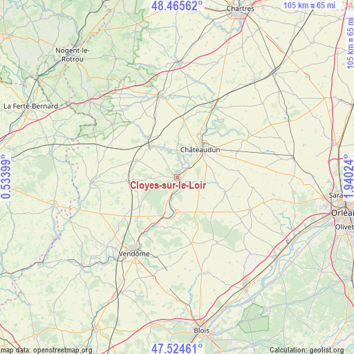
Cloyes-sur-le-Loir GPS coordinates[2]
47° 59' 50.136" North, 1° 14' 13.596" East
| Map corner | latitude | longitude |
|---|---|---|
| Upper-left | 48.46562°, | 0.53399° |
| Center: | 47.99726°, | 1.23711° |
| Lower-right: | 47.52461°, | 1.94024° |
| Map W x H: | 104.6×104.6 km | = 65×65mi |
| max Lat: | 51.07786° ⇑40.8% North |
| Cloyes-sur-le-Loir: | 47.99726° |
| min Lat: | ⇓59.2% South 41.3874° |
| min Long | Cloyes-sur-le-L | max Long |
| -5.08615° | 1.23711° | 9.52242° |
| W 33.7%⇐ | ⇒66.3% E |
Elevation
Elevation of Cloyes-sur-le-Loir is 98 m = 322 ft, and this is 95.7 m = 314 ft below average elevation for this country.
| Max E: |
2333 m = 7654 ft | 61.5% |
| Avg. | 193.7 m = 635 ft | |
| Cloyes-sur-le-Loir | 98 m = 322 ft | |
Min E: |
-1 m = -3 ft | 38.5% |
See also: France elevation on elevation.city.
Geographical zone
Cloyes-sur-le-Loir is located in North temperate zone (between Tropic of Cancer and the Arctic Circle). Distance of this North polar circle is 2064.4 km =1282.8 mi to North.| Distance of | km | miles | from Cloyes-sur-le-Loir |
|---|---|---|---|
| North Pole | 4670.3 | 2902 | to North |
| Arctic Circle | 2064.4 | 1282.8 | to North |
| Tropic Cancer | 2730.9 | 1696.9 | to South |
| Equator | 5336.8 | 3316.1 | to South |


Nearby cities:
15 places around Cloyes-sur-le-Loir: (largest is in red/bold)
• Arrou
13.8 km =8.6 mi,  324°
324°
• Châteaudun
11.1 km =6.9 mi,  42°
42°
• Châtillon-en-Dunois
13.8 km =8.6 mi,  343°
343°
• Courtalain
11.8 km =7.3 mi, 322°
• Droué
12.9 km =8 mi,  291°
291°
• Fréteval
12.1 km =7.5 mi,  190°
190°
• Jallans
13 km =8.1 mi,  48°
48°
• La Chapelle-du-Noyer
6.6 km =4.1 mi, 54°
• La Ville-aux-Clercs
14.3 km =8.9 mi,  232°
232°
• Lanneray
9.9 km =6.2 mi,  1°
1°
• Marboué
14.8 km =9.2 mi,  28°
28°
• Morée
10.4 km =6.5 mi,  181°
181°
• Saint-Denis-les-Ponts
9 km =5.6 mi, 30°
• Saint-Hilaire-la-Gravelle
8.9 km =5.5 mi,  198°
198°
• Saint-Hilaire-sur-Yerre
3.7 km =2.3 mi,  24°
24°
Sources, notices
• [Note1] Compared only with cities in France existing in our database
• [Src1] Map data: © OpenStreetMap contributors (CC-BY-SA)
• [Src2] Other city data from geonames.org with taken over terms of usage.
• [Src3] Geographical zone / Annual Mean Temperature by Robert A. Rohde @ Wikipedia
