Selommes geodata
Selommes (Centre) is a populated place; located in France in Europe/Paris (GMT+2) time zone. With population of 790 people, there are 10715 cities with bigger population in this country. Compared to other cities in France, 55.1% of cities are located further ↓South; 66.8% of cities are located further →East and 53.3% of cities have higher elevation than Selommes. Note1
Administrative division(s):
- Level 1: Centre
- Level 2: Département du Loir-et-Cher
- Level 3: Arrondissement de Vendôme
- Level 4: Selommes


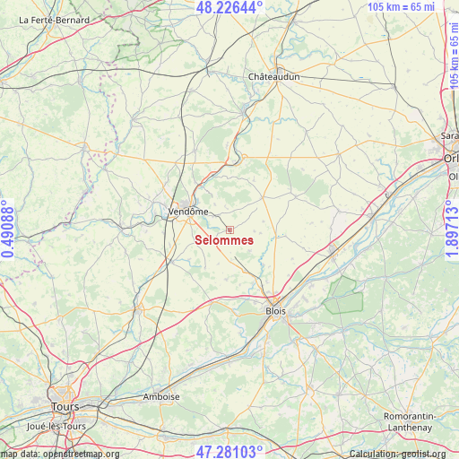
Selommes GPS coordinates[2]
47° 45' 21.168" North, 1° 11' 38.436" East
| Map corner | latitude | longitude |
|---|---|---|
| Upper-left | 48.22644°, | 0.49088° |
| Center: | 47.75588°, | 1.19401° |
| Lower-right: | 47.28103°, | 1.89713° |
| Map W x H: | 105.1×105.1 km | = 65.3×65.3mi |
| max Lat: | 51.07786° ⇑44.9% North |
| Selommes: | 47.75588° |
| min Lat: | ⇓55.1% South 41.3874° |
| min Long | Selommes | max Long |
| -5.08615° | 1.19401° | 9.52242° |
| W 33.2%⇐ | ⇒66.8% E |
Elevation
Elevation of Selommes is 121 m = 397 ft, and this is 72.7 m = 239 ft below average elevation for this country.
| Max E: |
2333 m = 7654 ft | 53.3% |
| Avg. | 193.7 m = 635 ft | |
| Selommes | 121 m = 397 ft | |
Min E: |
-1 m = -3 ft | 46.7% |
See also: France elevation on elevation.city.
Geographical zone
Selommes is located in North temperate zone (between Tropic of Cancer and the Arctic Circle). Distance of this North polar circle is 2091.2 km =1299.4 mi to North.| Distance of | km | miles | from Selommes |
|---|---|---|---|
| North Pole | 4697.1 | 2918.6 | to North |
| Arctic Circle | 2091.2 | 1299.4 | to North |
| Tropic Cancer | 2704 | 1680.2 | to South |
| Equator | 5310 | 3299.5 | to South |


Nearby cities:
15 places around Selommes: (largest is in red/bold)
• Areines
9 km =5.6 mi,  305°
305°
• Averdon
11 km =6.8 mi,  136°
136°
• Champigny-en-Beauce
6.6 km =4.1 mi, 137°
• Fréteval
15 km =9.3 mi,  4°
4°
• La Chapelle-Vendômoise
10 km =6.2 mi,  160°
160°
• Landes-le-Gaulois
11.3 km =7 mi,  183°
183°
• Marolles
14.6 km =9.1 mi, 144°
• Maves
12.9 km =8 mi,  96°
96°
• Naveil
12.9 km =8 mi,  290°
290°
• Oucques
10.5 km =6.5 mi,  45°
45°
• Pezou
13 km =8.1 mi,  342°
342°
• Saint-Firmin-des-Prés
11.2 km =7 mi,  327°
327°
• Saint-Ouen
10.7 km =6.6 mi, 307°
• Vendôme
10.4 km =6.5 mi, 293°
• Villerable
12.2 km =7.6 mi,  270°
270°
Sources, notices
• [Note1] Compared only with cities in France existing in our database
• [Src1] Map data: © OpenStreetMap contributors (CC-BY-SA)
• [Src2] Other city data from geonames.org with taken over terms of usage.
• [Src3] Geographical zone / Annual Mean Temperature by Robert A. Rohde @ Wikipedia
