Montverdun geodata
Montverdun (Auvergne-Rhône-Alpes) is a populated place; located in France in Europe/Paris (GMT+2) time zone. With population of 770 people, there are 10937 cities with bigger population in this country. Compared to other cities in France, 70.6% of cities are located further ↑North; 68.5% of cities are located further ←West and 85.7% of cities have lower elevation than Montverdun. Note1
Administrative division(s):
- Level 1: Auvergne-Rhône-Alpes
- Level 2: Département de la Loire
- Level 3: Arrondissement de Montbrison
- Level 4: Montverdun


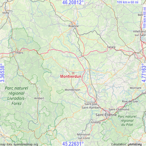
Montverdun GPS coordinates[2]
45° 43' 9.732" North, 4° 4' 6.6" East
| Map corner | latitude | longitude |
|---|---|---|
| Upper-left | 46.20812°, | 3.36538° |
| Center: | 45.71937°, | 4.0685° |
| Lower-right: | 45.22631°, | 4.77163° |
| Map W x H: | 109.2×109.2 km | = 67.9×67.9mi |
| max Lat: | 51.07786° ⇑70.6% North |
| Montverdun: | 45.71937° |
| min Lat: | ⇓29.4% South 41.3874° |
| min Long | Montverdun | max Long |
| -5.08615° | 4.0685° | 9.52242° |
| W 68.5%⇐ | ⇒31.5% E |
Elevation
Elevation of Montverdun is 357 m = 1171 ft, and this is 163.3 m = 536 ft above average elevation for this country.
| Max E: |
2333 m = 7654 ft | 14.3% |
| Montverdun | 357 m 1171 ft | |
| Avg. | 193.7 m = 635 ft | |
Min E: |
-1 m = -3 ft | 85.7% |
See also: France elevation on elevation.city.
Geographical zone
Montverdun is located in North temperate zone (between Tropic of Cancer and the Arctic Circle). Distance of this North polar circle is 2317.7 km =1440.2 mi to North.| Distance of | km | miles | from Montverdun |
|---|---|---|---|
| North Pole | 4923.5 | 3059.3 | to North |
| Arctic Circle | 2317.7 | 1440.2 | to North |
| Tropic Cancer | 2477.6 | 1539.5 | to South |
| Equator | 5083.5 | 3158.7 | to South |


Nearby cities:
15 places around Montverdun: (largest is in red/bold)
• Boën-sur-Lignon
5.9 km =3.7 mi,  306°
306°
• Champdieu
8.4 km =5.2 mi,  191°
191°
• Marcilly-le-Châtel
3.9 km =2.4 mi,  228°
228°
• Marcoux
4.5 km =2.8 mi,  257°
257°
• Nervieux
11.3 km =7 mi,  34°
34°
• Poncins
7.9 km =4.9 mi,  85°
85°
• Pralong
6.6 km =4.1 mi,  207°
207°
• Sail-sous-Couzan
7.9 km =4.9 mi,  282°
282°
• Saint-Bonnet-le-Courreau
11.6 km =7.2 mi,  235°
235°
• Saint-Laurent-la-Conche
11.7 km =7.3 mi,  109°
109°
• Saint-Sixte
9.1 km =5.7 mi, 312°
• Saint-Étienne-le-Molard
2.3 km =1.4 mi,  44°
44°
• Sainte-Agathe-la-Bouteresse
3.1 km =1.9 mi, 310°
• Savigneux
11.5 km =7.1 mi,  174°
174°
• Trelins
4.8 km =3 mi, 281°
Sources, notices
• [Note1] Compared only with cities in France existing in our database
• [Src1] Map data: © OpenStreetMap contributors (CC-BY-SA)
• [Src2] Other city data from geonames.org with taken over terms of usage.
• [Src3] Geographical zone / Annual Mean Temperature by Robert A. Rohde @ Wikipedia
