Nervieux geodata
Nervieux (Auvergne-Rhône-Alpes) is a populated place; located in France in Europe/Paris (GMT+2) time zone. With population of 796 people, there are 10658 cities with bigger population in this country. Compared to other cities in France, 69.2% of cities are located further ↑North; 69.3% of cities are located further ←West and 83.4% of cities have lower elevation than Nervieux. Note1
Administrative division(s):
- Level 1: Auvergne-Rhône-Alpes
- Level 2: Département de la Loire
- Level 3: Arrondissement de Montbrison
- Level 4: Nervieux


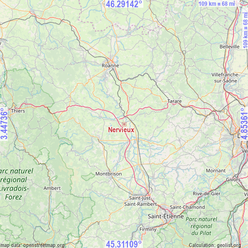
Nervieux GPS coordinates[2]
45° 48' 12.276" North, 4° 9' 1.764" East
| Map corner | latitude | longitude |
|---|---|---|
| Upper-left | 46.29142°, | 3.44736° |
| Center: | 45.80341°, | 4.15049° |
| Lower-right: | 45.31109°, | 4.85361° |
| Map W x H: | 109×109 km | = 67.7×67.7mi |
| max Lat: | 51.07786° ⇑69.2% North |
| Nervieux: | 45.80341° |
| min Lat: | ⇓30.8% South 41.3874° |
| min Long | Nervieux | max Long |
| -5.08615° | 4.15049° | 9.52242° |
| W 69.3%⇐ | ⇒30.7% E |
Elevation
Elevation of Nervieux is 327 m = 1073 ft, and this is 133.3 m = 437 ft above average elevation for this country.
| Max E: |
2333 m = 7654 ft | 16.6% |
| Nervieux | 327 m 1073 ft | |
| Avg. | 193.7 m = 635 ft | |
Min E: |
-1 m = -3 ft | 83.4% |
See also: France elevation on elevation.city.
Geographical zone
Nervieux is located in North temperate zone (between Tropic of Cancer and the Arctic Circle). Distance of this North polar circle is 2308.3 km =1434.3 mi to North.| Distance of | km | miles | from Nervieux |
|---|---|---|---|
| North Pole | 4914.2 | 3053.5 | to North |
| Arctic Circle | 2308.3 | 1434.3 | to North |
| Tropic Cancer | 2486.9 | 1545.3 | to South |
| Equator | 5092.9 | 3164.6 | to South |


Nearby cities:
15 places around Nervieux: (largest is in red/bold)
• Balbigny
3.5 km =2.2 mi,  60°
60°
• Bussières
10 km =6.2 mi,  69°
69°
• Civens
8.3 km =5.2 mi,  108°
108°
• Feurs
9.8 km =6.1 mi,  142°
142°
• Montverdun
11.3 km =7 mi,  214°
214°
• Neulise
10.8 km =6.7 mi,  12°
12°
• Néronde
7.6 km =4.7 mi, 61°
• Poncins
8.8 km =5.5 mi,  170°
170°
• Pouilly-lès-Feurs
6.4 km =4 mi,  95°
95°
• Rozier-en-Donzy
9.8 km =6.1 mi,  91°
91°
• Saint-Germain-Laval
11 km =6.8 mi,  287°
287°
• Saint-Jodard
8.6 km =5.3 mi,  349°
349°
• Saint-Marcel-de-Félines
7.8 km =4.8 mi,  23°
23°
• Saint-Étienne-le-Molard
9.1 km =5.7 mi, 211°
• Épercieux-Saint-Paul
4.8 km =3 mi, 108°
Sources, notices
• [Note1] Compared only with cities in France existing in our database
• [Src1] Map data: © OpenStreetMap contributors (CC-BY-SA)
• [Src2] Other city data from geonames.org with taken over terms of usage.
• [Src3] Geographical zone / Annual Mean Temperature by Robert A. Rohde @ Wikipedia
