Mont-sur-Meurthe geodata
Mont-sur-Meurthe (Grand Est) is a populated place; located in France in Europe/Paris (GMT+2) time zone. With population of 909 people, there are 9582 cities with bigger population in this country. Compared to other cities in France, 69.7% of cities are located further ↓South; 91.4% of cities are located further ←West and 71% of cities have lower elevation than Mont-sur-Meurthe. Note1
Administrative division(s):
- Level 1: Grand Est
- Level 2: Meurthe-et-Moselle
- Level 3: Arrondissement de Lunéville
- Level 4: Mont-sur-Meurthe


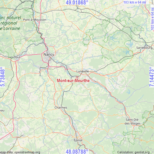
Mont-sur-Meurthe GPS coordinates[2]
48° 33' 19.512" North, 6° 26' 29.796" East
| Map corner | latitude | longitude |
|---|---|---|
| Upper-left | 49.01868°, | 5.73848° |
| Center: | 48.55542°, | 6.44161° |
| Lower-right: | 48.08788°, | 7.14473° |
| Map W x H: | 103.5×103.5 km | = 64.3×64.3mi |
| max Lat: | 51.07786° ⇑30.3% North |
| Mont-sur-Meurthe: | 48.55542° |
| min Lat: | ⇓69.7% South 41.3874° |
| min Long | Mont-sur-Meurth | max Long |
| -5.08615° | 6.44161° | 9.52242° |
| W 91.4%⇐ | ⇒8.6% E |
Elevation
Elevation of Mont-sur-Meurthe is 224 m = 735 ft, and this is 30.3 m = 99 ft above average elevation for this country.
| Max E: |
2333 m = 7654 ft | 29% |
| Mont-sur-Meurthe | 224 m 735 ft | |
| Avg. | 193.7 m = 635 ft | |
Min E: |
-1 m = -3 ft | 71% |
See also: France elevation on elevation.city.
Geographical zone
Mont-sur-Meurthe is located in North temperate zone (between Tropic of Cancer and the Arctic Circle). Distance of this North polar circle is 2002.3 km =1244.2 mi to North.| Distance of | km | miles | from Mont-sur-Meurthe |
|---|---|---|---|
| North Pole | 4608.2 | 2863.4 | to North |
| Arctic Circle | 2002.3 | 1244.2 | to North |
| Tropic Cancer | 2792.9 | 1735.4 | to South |
| Equator | 5398.9 | 3354.7 | to South |


Nearby cities:
15 places around Mont-sur-Meurthe: (largest is in red/bold)
• Chanteheux
7.9 km =4.9 mi,  53°
53°
• Croismare
10.6 km =6.6 mi,  63°
63°
• Crévic
9.7 km =6 mi,  343°
343°
• Damelevières
4.2 km =2.6 mi,  275°
275°
• Dombasle-sur-Meurthe
9.5 km =5.9 mi,  317°
317°
• Einville-au-Jard
11.6 km =7.2 mi,  15°
15°
• Gerbéviller
8.3 km =5.2 mi,  142°
142°
• Hériménil
4.2 km =2.6 mi,  70°
70°
• Jolivet
7.3 km =4.5 mi,  38°
38°
• Lunéville
5.7 km =3.5 mi, 42°
• Marainviller
12.3 km =7.6 mi, 72°
• Rehainviller
2.3 km =1.4 mi, 68°
• Rosières-aux-Salines
9.1 km =5.7 mi,  297°
297°
• Saint-Clément
12.2 km =7.6 mi,  102°
102°
• Sommerviller
9.8 km =6.1 mi,  330°
330°
Sources, notices
• [Note1] Compared only with cities in France existing in our database
• [Src1] Map data: © OpenStreetMap contributors (CC-BY-SA)
• [Src2] Other city data from geonames.org with taken over terms of usage.
• [Src3] Geographical zone / Annual Mean Temperature by Robert A. Rohde @ Wikipedia
