Damelevières geodata
Damelevières (Grand Est) is a populated place; located in France in Europe/Paris (GMT+2) time zone. With population of 2,860 people, there are 3412 cities with bigger population in this country. Compared to other cities in France, 69.8% of cities are located further ↓South; 91% of cities are located further ←West and 70.9% of cities have lower elevation than Damelevières. Note1
Administrative division(s):
- Level 1: Grand Est
- Level 2: Meurthe-et-Moselle
- Level 3: Arrondissement de Lunéville
- Level 4: Damelevières


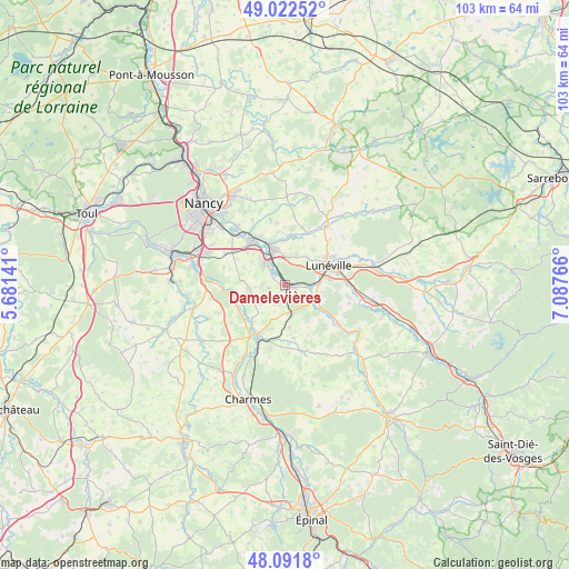
Damelevières GPS coordinates[2]
48° 33' 33.48" North, 6° 23' 4.308" East
| Map corner | latitude | longitude |
|---|---|---|
| Upper-left | 49.02252°, | 5.68141° |
| Center: | 48.5593°, | 6.38453° |
| Lower-right: | 48.0918°, | 7.08766° |
| Map W x H: | 103.5×103.5 km | = 64.3×64.3mi |
| max Lat: | 51.07786° ⇑30.2% North |
| Damelevières: | 48.5593° |
| min Lat: | ⇓69.8% South 41.3874° |
| min Long | Damelevières | max Long |
| -5.08615° | 6.38453° | 9.52242° |
| W 91%⇐ | ⇒9% E |
Elevation
Elevation of Damelevières is 223 m = 732 ft, and this is 29.3 m = 96 ft above average elevation for this country.
| Max E: |
2333 m = 7654 ft | 29.1% |
| Damelevières | 223 m 732 ft | |
| Avg. | 193.7 m = 635 ft | |
Min E: |
-1 m = -3 ft | 70.9% |
See also: France elevation on elevation.city.
Geographical zone
Damelevières is located in North temperate zone (between Tropic of Cancer and the Arctic Circle). Distance of this North polar circle is 2001.9 km =1243.9 mi to North.| Distance of | km | miles | from Damelevières |
|---|---|---|---|
| North Pole | 4607.8 | 2863.2 | to North |
| Arctic Circle | 2001.9 | 1243.9 | to North |
| Tropic Cancer | 2793.4 | 1735.7 | to South |
| Equator | 5399.3 | 3355 | to South |


Nearby cities:
15 places around Damelevières: (largest is in red/bold)
• Bayon
10.7 km =6.6 mi,  207°
207°
• Chanteheux
11.4 km =7.1 mi,  68°
68°
• Crévic
9 km =5.6 mi,  9°
9°
• Dombasle-sur-Meurthe
6.9 km =4.3 mi,  341°
341°
• Hériménil
8.3 km =5.2 mi,  83°
83°
• Jolivet
10.2 km =6.3 mi,  59°
59°
• Lunéville
8.9 km =5.5 mi, 65°
• Mont-sur-Meurthe
4.2 km =2.6 mi,  95°
95°
• Rehainviller
6.3 km =3.9 mi,  86°
86°
• Rosières-aux-Salines
5.4 km =3.4 mi,  314°
314°
• Saint-Nicolas-de-Port
10.1 km =6.3 mi,  320°
320°
• Sommerviller
8.1 km =5 mi,  355°
355°
• Tonnoy
9.8 km =6.1 mi,  265°
265°
• Varangéville
9.9 km =6.2 mi,  330°
330°
• Ville-en-Vermois
11.4 km =7.1 mi,  302°
302°
Sources, notices
• [Note1] Compared only with cities in France existing in our database
• [Src1] Map data: © OpenStreetMap contributors (CC-BY-SA)
• [Src2] Other city data from geonames.org with taken over terms of usage.
• [Src3] Geographical zone / Annual Mean Temperature by Robert A. Rohde @ Wikipedia
