Crévic geodata
Crévic (Grand Est) is a populated place; located in France in Europe/Paris (GMT+2) time zone. With population of 935 people, there are 9342 cities with bigger population in this country. Compared to other cities in France, 71.8% of cities are located further ↓South; 91.1% of cities are located further ←West and 70.1% of cities have lower elevation than Crévic. Note1
Administrative division(s):
- Level 1: Grand Est
- Level 2: Meurthe-et-Moselle
- Level 3: Arrondissement de Lunéville
- Level 4: Crévic


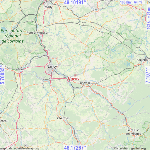
Crévic GPS coordinates[2]
48° 38' 21.948" North, 6° 24' 14.328" East
| Map corner | latitude | longitude |
|---|---|---|
| Upper-left | 49.10191°, | 5.70085° |
| Center: | 48.63943°, | 6.40398° |
| Lower-right: | 48.17267°, | 7.1071° |
| Map W x H: | 103.3×103.3 km | = 64.2×64.2mi |
| max Lat: | 51.07786° ⇑28.2% North |
| Crévic: | 48.63943° |
| min Lat: | ⇓71.8% South 41.3874° |
| min Long | Crévic | max Long |
| -5.08615° | 6.40398° | 9.52242° |
| W 91.1%⇐ | ⇒8.9% E |
Elevation
Elevation of Crévic is 220 m = 722 ft, and this is 26.3 m = 86 ft above average elevation for this country.
| Max E: |
2333 m = 7654 ft | 29.9% |
| Crévic | 220 m 722 ft | |
| Avg. | 193.7 m = 635 ft | |
Min E: |
-1 m = -3 ft | 70.1% |
See also: France elevation on elevation.city.
Geographical zone
Crévic is located in North temperate zone (between Tropic of Cancer and the Arctic Circle). Distance of this North polar circle is 1993 km =1238.4 mi to North.| Distance of | km | miles | from Crévic |
|---|---|---|---|
| North Pole | 4598.9 | 2857.6 | to North |
| Arctic Circle | 1993 | 1238.4 | to North |
| Tropic Cancer | 2802.3 | 1741.3 | to South |
| Equator | 5408.2 | 3360.5 | to South |


Nearby cities:
15 places around Crévic: (largest is in red/bold)
• Art-sur-Meurthe
10.3 km =6.4 mi,  281°
281°
• Cerville
9.2 km =5.7 mi,  313°
313°
• Chanteheux
10.2 km =6.3 mi,  117°
117°
• Damelevières
9 km =5.6 mi,  189°
189°
• Dombasle-sur-Meurthe
4.3 km =2.7 mi,  237°
237°
• Einville-au-Jard
6.2 km =3.9 mi,  72°
72°
• Haraucourt
3.9 km =2.4 mi, 309°
• Jolivet
8.2 km =5.1 mi, 116°
• Lunéville
8.4 km =5.2 mi,  128°
128°
• Mont-sur-Meurthe
9.7 km =6 mi,  163°
163°
• Rehainviller
9.8 km =6.1 mi,  150°
150°
• Rosières-aux-Salines
7.4 km =4.6 mi,  225°
225°
• Saint-Nicolas-de-Port
8 km =5 mi,  261°
261°
• Sommerviller
2.2 km =1.4 mi,  247°
247°
• Varangéville
6.3 km =3.9 mi,  267°
267°
Sources, notices
• [Note1] Compared only with cities in France existing in our database
• [Src1] Map data: © OpenStreetMap contributors (CC-BY-SA)
• [Src2] Other city data from geonames.org with taken over terms of usage.
• [Src3] Geographical zone / Annual Mean Temperature by Robert A. Rohde @ Wikipedia
